- Hundreds of brush fires burn across North Carolina Saturday; several fires still burning Sunday
- Texas’ biggest wildfire started a year ago. How does the Panhandle look now?
- To her, Hurricane Helene debris isn’t trash. It is full of memories — and she’s returning them
- Bills introduced a year after state’s largest blaze seek to limit wildfires
- A year after Texas’ largest wildfire, Panhandle residents tugged between hope and anxiety
Frequent lightning, damaging winds expected in Raleigh
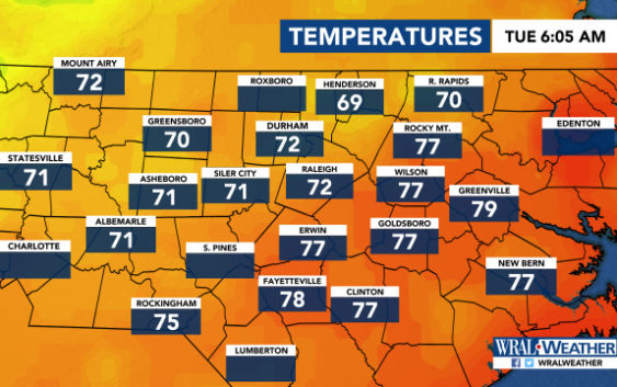
Raleigh, N.C. — The Triangle and southeastern areas are under a level 2 threat for severe weather, with frequent lightning, heavy rain and damaging winds possible, WRAL meteorologist Elizabeth Gardner said.
Areas to the northwest are under a level 1 alert.
A cold front is moving eastward, pushing the storms through with cooler temperatures.
Tuesday’s high is expected to be 80 degrees.
Rain fell early Tuesday morning but was clearing around 6 a.m. The morning commute should be fairly clear, Gardner said.
More rain moves in during lunchtime, bringing the chance for scattered severe storms.

Those storms will move eastward throughout the afternoon, and a bigger system moves through the Triangle in the evening and into the night.
More than 2 inches of rain is expected to fall in Raleigh on Tuesday.
Skies will clear after midnight, Gardner said.
Wednesday will be sunny with a high of 84 degrees.
