- 'A little emotional': Hurricanes equipment manager got seconds in goal, memory to last a lifetime
- WMO retires three hurricane names after devastating 2024 season
- Beryl removed from future hurricane naming lists
- Hurricane names Helene, Milton and Beryl are now retired
- Hurricane Helene's name retired after deadly 2024 impact on US
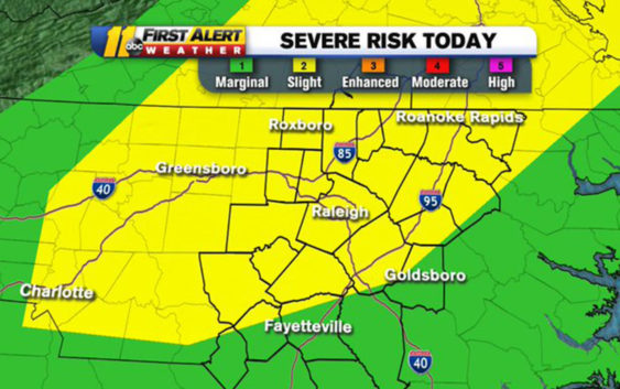
Raleigh, Fayetteville areas could see severe weather this afternoon
ABC11 is in First Alert Mode as severe weather is set to push through Wednesday afternoon.
Most areas in the Triangle are at a slight risk, while areas south of Fayetteville are at a marginal risk.
Most areas in the Triangle are at a slight risk, while areas south of Fayetteville are at a marginal risk.
Over 110 million Americans under a risk for severe weather today, including our entire viewing area. Biggest threat = damaging winds. May see some hail in spots too. #ncwx pic.twitter.com/LT1hsUEtzs
— Don Schwenneker (@BigweatherABC11) August 7, 2019
Don “Big Weather” Schwenneker said thunderstorms will roll in around 2 p.m. and continue into the early evening.
He said the storms could become strong to severe and could produce damaging winds and flooding downpours.
Big Weather said damaging winds will be our biggest threat, adding that some areas could see hail.
After storms pass, he said we should see mostly sunny skies for the rest of the week.
Copyright © 2019 WTVD-TV. All Rights Reserved.