- National memorial to honor NC firefighter who died on duty during Hurricane Helene
- Gov. Josh Stein extends State of Emergency for western NC wildfires
- Governor Stein extends state of emergency for NC wildfire threat
- Governor Stein extends emergency in 34 NC counties amid wildfire threat
- Texans can buy emergency preparation supplies tax-free April 26-28 ahead of severe weather season
Triangle under Level 1 risk for severe weather today
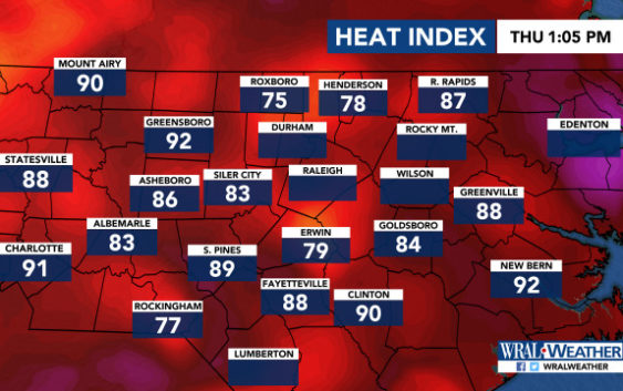
Raleigh, N.C. — The Triangle and much of central North Carolina are under a Level 1 risk for severe weather Thursday and some of the storms could be strong.
WRAL meteorologist Kat Campbell said the storms could fire up in the afternoon and last into the evening hours.
The storms could bring downpours, lightning, gusty winds and hail, she said.
But the rest of central North Carolina could also see storms with heavy rain and gusty winds.
There’s a 50 percent chance of rain in the Triangle.
Temperatures will be hot, with a high of 89 degrees in Raleigh but a heat index of 98 by the late afternoon.
Rocky Mount will feel like 102 degrees, and Fayetteville will feel like 104 degrees.
A front is bringing warm, moist air from the Gulf of Mexico, keeping the humidity at oppressive levels.
The weekend stays hot, with highs at 92 degrees and intense humidity staying put.
