- Seven months after Hurricane Helene, Chimney Rock rebuilds with resilience
- Wildfire in New Jersey Pine Barrens expected to grow before it’s contained, officials say
- Storm damage forces recovery efforts in Lancaster, Chester counties
- Evacuation orders lifted as fast-moving New Jersey wildfire burns
- Heartbreak for NC resident as wildfire reduces lifetime home to ashes
Tropical Storm Chantal racing east across North Atlantic
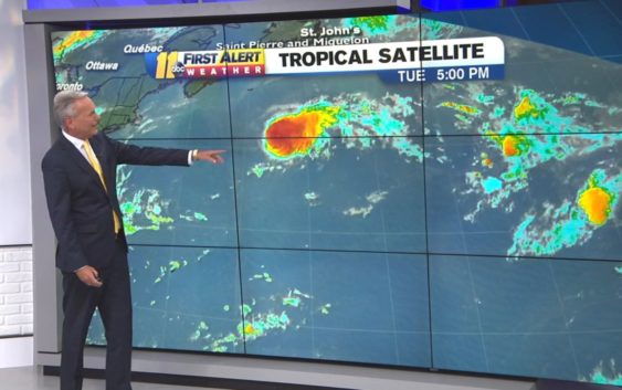
As of Wednesday morning, Tropical Storm Chantal continued to race eastward over the North Atlantic, approximately 445 miles south of Cape Race, Newfoundland. Maximum sustained winds were near 40 mph. Chantal was moving eastward at about 22 mph.
Moderate to strong vertical wind shear is currently impacting Chantal, pushing most of the deep convection to the east of the center of circulation. This wind shear will likely prevent Chantal from strengthening over the next couple of days.
However, Chantal is expected to slow its forward speed by the weekend and will turn toward the south and southwest. As it slows and makes this turn, Chantal will start to encounter some warmer water and lighter wind shear and may be able to strengthen a bit. However, Chantal will not directly impact any land over the next several days.
We are also tracking a couple of tropical waves in the basin. The main two waves are found near 35 west and 60 west. Another tropical wave may be emerging from the west coast of Africa, while a forth wave is moving through Central America. These waves are moving west at an average speed of 6-8 degrees longitude per day.
None of these waves are expected to develop over the next several days due to the presence of strong wind shear and dry, dusty air. However, the tropical wave moving through Central America will send some tropical moisture northward over the weekend and could produce locally heavy rainfall over parts of Texas, Louisiana and Mississippi, late this week into the weekend.
By AccuWeather Senior Meteorologist Rob Miller
Copyright © 2019 WTVD-TV. All Rights Reserved.