- Seven months after Hurricane Helene, Chimney Rock rebuilds with resilience
- Wildfire in New Jersey Pine Barrens expected to grow before it’s contained, officials say
- Storm damage forces recovery efforts in Lancaster, Chester counties
- Evacuation orders lifted as fast-moving New Jersey wildfire burns
- Heartbreak for NC resident as wildfire reduces lifetime home to ashes
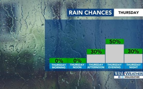
Severe weather moving into Triangle late afternoon could bring heavy rain, lightning
Raleigh, N.C. — The entire viewing area and most of the state is under a level 1 threat for severe weather for Thursday.
While the early afternoon should be quiet, storms are expected to move into central North Carolina late afternoon and stick around through midnight, according to WRAL meteorologist Elizabeth Gardner.
“Some of these storms may be on the stronger side,” Gardner said. “Damaging winds, heavy rain, hail and frequent lightning are possible.”
Download the WRAL Weather App to get severe weather alerts.

Despite the incoming storms, Thursday afternoon will be hot, with a high around 93 degrees.
Most of central North Carolina will be under a level 1 threat for severe weather on Friday, too, as another front approaches from the south.
Those storms will move in late afternoon or early evening Friday.
“It looks like a rainy evening,” Gardner said. “It is not looking good.”
Friday’s high will be 89 degrees.
Showers will linger Saturday, but high temperatures drop to the low 80s.
A break in the rain should come Sunday.
