- Tropical Storm Sara threatens to bring flash floods and mudslides to Central America
- Hurricane-stricken Tampa Bay Rays to play 2025 season at Yankees' spring training field in Tampa
- Utah scores 3 goals in 2 1/2 minutes in 3rd, Vejmelka has 49 saves in 4-1 win over Hurricanes
- Driver dies after crashing off hurricane-damaged highway in North Carolina
- Body buried in North Carolina carried to Tennessee by Hurricane Helene floodwaters
Tropical Storm Ivo to batter western Mexico with flooding downpours, mudslides and rough surf

Ivo is expected to become the eastern Pacific Ocean’s next hurricane as it parallels the western coast of Mexico and unleashes dangerous surf and flooding rainfall into the weekend.
On Wednesday afternoon, an area of disturbed weather off the western coast of Mexico organized and strengthened into Tropical Storm Ivo, the ninth named tropical system this year in the basin. The storm is expected to continue strengthening as it remains in an area of warm water and low wind shear. Hurricane status is likely to be reached by the end of the week.

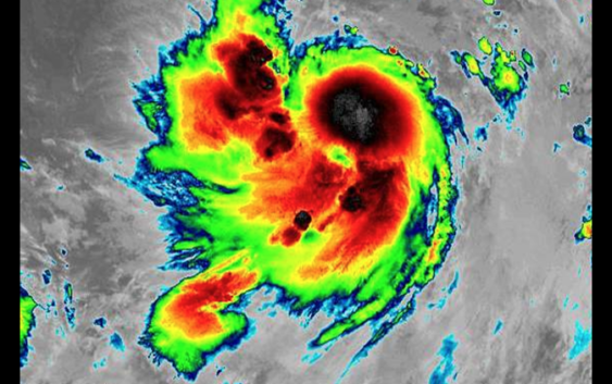
This satellite image shows Ivo off the southwestern coast of Mexico early Thursday morning, Aug. 22, 2019. (NOAA)
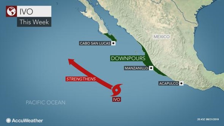
“Any strong winds generated by the intensifying tropical system will remain well offshore of Mexico,” AccuWeather Hurricane Expert Dan Kottlowski said. “However, heavy rainfall and the risk of flooding and mudslides are likely to hug part of the western coast of Mexico as the center of the storm moves along a northwest path offshore.”
The risk of flash flooding and mudslides will be greatest along the western slopes of the Sierra Madre Occidental Mountains. Those living or vacationing within the states of Colima, Jalisco, Nayarit and part of Sinaloa should keep a watchful eye out for rapidly rising floodwaters and be ready to move to higher ground if necessary.
Motorists are reminded to never attempt to drive through flooded roadways as the water may be deeper than it appears and the road surface underneath could be compromised.
Downpours will spread through Baja California Sur, including Cabo San Lucas, into Saturday, disrupting beach plans and outdoor activities. Localized flooding may also occur.
“Rough and dangerous surf will impact west coastal areas of Mexico, including the southern and western coastal areas of Baja California,” Kottlowski said.


ivo
The frequency and intensity of rip currents is also likely to increase. If caught in a rip current, do not panic or fight the current. Swim parallel to the coast until you escape the rip current. You should then swim at an angle, away from the current and toward the beach.
“As Ivo enters colder waters west of Baja California this weekend, it is likely to diminish before reaching waters off the coast of California,” according to AccuWeather Senior Meteorologist Alex Sosnowski.
Even with the storm dissipating, an increase in surf action is likely along the south-facing beaches of Southern California late this weekend and early next week.
“Ivo may also spread some clouds into parts of California early next week,” AccuWeather Meteorologist and western United States blogger Brian Thompson said.
It is possible that a stray shower or thunderstorm will be sparked in the Southern California mountains during this time frame, but unfortunately for the parched Southwest, no meaningful rainfall is expected.
Even with Ivo taking a more northern track than we have seen so far this season, it doesn”t look like it will help to add much fuel to the North American monsoon, according to Thompson.
“With this system being a swing and a miss, there aren”t going to be many opportunities for widespread monsoon thunderstorms through next week,” he added.
Elsewhere in the East Pacific, there are no other areas being monitored in the short term for tropical development. The area of disturbed weather that AccuWeather meteorologists were monitoring for possible impacts to Hawaii next week has fizzled and lost its opportunity to become a tropical storm.
Download the free AccuWeather app to stay alert of the latest tropical developments around the globe. Keep checking back for updates on AccuWeather.com and stay tuned to the AccuWeather Network on DirecTV, Frontier and Verizon Fios.