- Seven months after Hurricane Helene, Chimney Rock rebuilds with resilience
- Wildfire in New Jersey Pine Barrens expected to grow before it’s contained, officials say
- Storm damage forces recovery efforts in Lancaster, Chester counties
- Evacuation orders lifted as fast-moving New Jersey wildfire burns
- Heartbreak for NC resident as wildfire reduces lifetime home to ashes
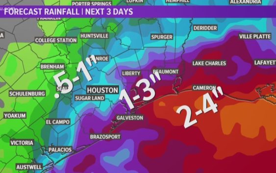
Houston Forecast: Heavy rain and flooding possible this weekend

Deep tropical moisture continues to move in from the Gulf of Mexico and this will keep our tropical downpours in place through Saturday. As of Friday afternoon, isolated areas have already picked up 3 inches of rain, and more is on the way. This brings street flooding concerns for many. Exercise caution while driving and avoid flooded area. Never cross inundated roadways
We need the rain with the latest drought monitor including Harris County under abnormally dry conditions. Of course we don’t need the flooding.
Next week the rain moves out and it is all about the heat! Temperatures return the upper 90’s.
Looking ahead (which of course things can change) we may see our first cool front around Labor Day. Fingers crossed if you’re ready for some change.
Tropics:
Tropical Depression ‘Chantal’ is expected to be nothing but a remnant low in the next 24 to 48 hours. It is no threat to land and well out in the open Atlantic waters.
There is also a broad area of disturbed weather near the Bahamas. It has a low (30%) chance for development over the next 5 days as what there is of it drifts up the Atlantic coast of Florida. This one is no threat to us.
Although both are weak, these two systems may be a sign that the tropics are ready to get busy. Be sure to watch the weather at least once a day on KHOU11 News and stay weather aware with us as we enter the busy time of hurricane season.
WEATHER RADAR: Track rain & storms across Texas
GET ALERTS ON THE GO: Download the KHOU 11 app and follow us on Facebook and Twitter.