- Lighter winds help crews fighting wildfires in South and North Carolina
- Austin is at a 'potentially historic' risk of wildfires Tuesday. Here's how to prepare.
- South Carolina's governor declares State of Emergency as massive wildfire grows to 1,600 acres
- Staying weather alert: How to find your safe place during severe weather
- Wildfires persist across Carolinas amid windy, dry conditions
Tropical Storm Dorian moves towards Puerto Rico, Tropical Depression 6 forms off Carolina coast

CHARLOTTE, N.C. — The tropics are getting more active as we track Tropical Storm Dorian and Tropical Depression Six, the latter of which formed Monday off the Carolina coast.
Tropical Storm Dorian formed Saturday evening. Dorian has a window to continue strengthening between now and Wednesday before it encounters more wind shear and encounters higher terrain. Those harsher conditions could impend the storm’s ability to strengthen.
The current forecast track from the National Hurricane Center shows it becoming a hurricane after it passes over the Lesser Antilles and nears Puerto Rico by mid week. Dorian is expected to bring tropical storm conditions to Barbados Monday evening into Monday night before tracking between St. Lucia and St. Vincent & The Grenadines late Monday night into Tuesday morning.
Once it encounters more wind shear and the mountainous terrain of Hispanola later in the week, it will weaken. What happens next is the big question.
Newly formed Tropical Depression Six is located midway between the outer banks of North Carolina and Bermuda. Rough surf is possible as a result of the storm but the storm is far enough offshore that its effects on the coast should be limited. The storm will pick up northeastward speed by Wednesday and by the end of the week it heads towards Nova Scotia and Newfoundland.
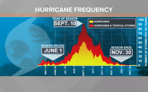
Climatologically speaking, it’s about time for the tropics to turn more active. Even though hurricane season in the Atlantic Basin started on June 1, the bulk of tropical storms and hurricanes occur after August 20. This is because we have the warmest waters of the year at this time and tropical systems feed off of warm water.

WUSA
The season lasts until November 30. Through August 24th, we’ve have had 4 named storms.
The next name after Dorian is Erin. The World Meteorological Organization makes the list of names. There are 6 lists and storms that have had an historic significance have their names retired. There are also different lists for different parts of the world using names in the languages that are indigenous in that region.
RELATED: FORECAST: Cool and cloudy for another day
RELATED: Person struck by lightning in Marion, numerous tress toppled during storms
RELATED: Lightning strikes kill 5, injure over 100 in eastern Europe’s Tatra Mountains
RELATED: Extensive tree damage in Statesville after severe weather
RELATED: Two rescued from flooded car during Charlotte storms
RELATED: 7K without power after severe storm brings wind, hail to Charlotte