- As wildfires grip South Carolina, governor warns: Burn and you’ll go to jail
- Hundreds of brush fires burn across North Carolina Saturday; several fires still burning Sunday
- Texas’ biggest wildfire started a year ago. How does the Panhandle look now?
- To her, Hurricane Helene debris isn’t trash. It is full of memories — and she’s returning them
- Bills introduced a year after state’s largest blaze seek to limit wildfires
Hurricane Dorian a Very Serious Threat to Florida

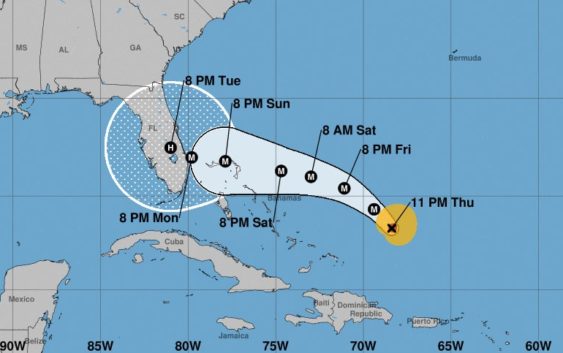
Hurricane Dorian reached category two status on Thursday night with winds up to 105 mph near its still small but intensifying inner core. It is currently moving northwest just east of the Bahamas. At the moment, there is still a bit of dry air nearby slowing the storm’s growth, but all that will change over the next three to four days.
Unfortunately, there still remains quite a bit of uncertainty with Dorian. Forecast models are in good agreement of its general current track through Friday at which point it will begin to slow down and make a hard left towards the Florida peninsula. Just how hard a turn, how slow it moves and what might happen later in the forecast is still unpredictable.
The storm is forecast to move west after it encounters a high pressure system over the east coast. High pressure, which spins clockwise, acts as a steering mechanism for storms like Dorian. Eventually, the high will begin to push off the east coast and erode a bit. The timing and shape of that change is critical to where Dorian will eventually end up. If it were to happen sooner, there are some models that show the storm turning north before making landfall and scraping the coastline of Florida. Others show it moving across Florida and into the eastern Gulf before moving north and eventually northeast.
Making matters more concerning is the fact that the storm should encounter low shear and very warm waters as it approaches the U.S. coastline. At this point the National Hurricane Center is projecting Dorian will be a strong category three or category four storm as it inches toward Florida.
But beyond the wind and storm surge at the point of landfall somewhere between Miami and the central Florida coast, this is expected to be a rather slow moving storm. After making landfall sometime early Tuesday morning, the storm could meander northward over Florida for two days. If that were to play out, the state will have to deal with tremendous amounts of rainfall in addition to everything else a major hurricane brings with it.
There are so many factors to consider; forecast models are still just struggling to pinpoint a track beyond the next couple of days. It is why the “cone of uncertainty” from the National Hurricane Center covers the entire state of Florida.
While this won’t impact us here in Texas, we certainly understand the impact of a storm like Dorian. And anyone with interests in Florida and other parts of the northern coast of the Gulf of Mexico and southeast U.S. coastline should be monitoring this extremely closely.