- Charlotte-based marketing agency announces $20,000 Creative Campaign Grant to help communities after Hurricane Helene
- Artists transform hurricane aftermath into hoop-inspired masterpieces at Charlotte exhibit
- NC's cost for Hurricane Helene damage is nearly $60 billion, state says
- State to develop drone program to better respond to disasters like Helene, Florence
- South Carolina residents face deadline to get storm debris out to the curb after Hurricane Helene
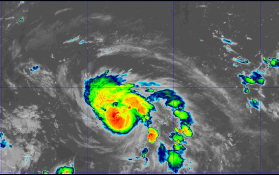
Hurricane Dorian now Category 2 storm; forecast to become a Major Hurricane later Friday

CHARLOTTE, N.C. — Here’s the latest on Hurricane Dorian
As of the 5 a.m. et update from the National Hurricane Center
LOCATION: 260 OF THE SOUTHEASTERN BAHAMAS
MAXIMUM SUSTAINED WINDS: 105 MPH
MOVEMENT: NW AT 12 MPH
Dorian is a Category 2 hurricane with sustained winds of 105 mph and is expected to make landfall in Florida as a Category 4 hurricane next week, according to the National Hurricane Center.
The storm is moving northwest at 12 mph. It is 295 miles east northeast of the southeastern Bahamas. The National Hurricane Center predicts Dorian will become a Major Hurricane later Friday.
A Hurricane Watch is in effect for Northwestern Bahamas.
On this track, Dorian should move over the Atlantic well east of the southeastern and central Bahamas Thursday night and on Friday, approach the northwestern Bahamas Saturday, and move near or over portions of the northwest Bahamas on Sunday.
Dorian is expected to become a major hurricane on Friday and remain an extremely dangerous hurricane through the weekend.
Swells are likely to begin affecting the east-facing shores of the Bahamas and the southeastern United States coast during the next few days. These swells are likely to cause life-threatening surf and rip current conditions.
Flooding will be a major concern for Florida. Rainfall rates, combined with storm surge, could result in life-threatening flash floods.
The storm is feeding off the warm, open waters of the Atlantic Ocean north of the Turks and Caicos Islands.
It is still not known exactly where the storm will make landfall but forecasts believe it will likely be in Florida. The uncertainty, which is commonly portrayed in the forecast track’s “cone of uncertainty,” will shrink as the storm moves closer to shore.
RELATED: 5 Things to Know About Hurricane Dorian
Panovich said everyone living along the Southeast coast should be paying attention. The track could shift.
“Residents in these areas should ensure that they have their hurricane plan in place and not focus on the exact forecast track of Dorian’s center,” according to the National Hurricane Center.
Regardless of where the storm ultimately makes landfall, heavy rain can be expected in across the Southeast next week, including in portions of North Carolina, South Carolina, Georgia, and Florida.
RELATED: Airlines offer travel waivers as Dorian reaches hurricane strength
RELATED: Person struck by lightning in Marion, numerous tress toppled during storms
RELATED: Lightning strikes kill 5, injure over 100 in eastern Europe’s Tatra Mountains
RELATED: Extensive tree damage in Statesville after severe weather
RELATED: Two rescued from flooded car during Charlotte storms