- Seven months after Hurricane Helene, Chimney Rock rebuilds with resilience
- Wildfire in New Jersey Pine Barrens expected to grow before it’s contained, officials say
- Storm damage forces recovery efforts in Lancaster, Chester counties
- Evacuation orders lifted as fast-moving New Jersey wildfire burns
- Heartbreak for NC resident as wildfire reduces lifetime home to ashes
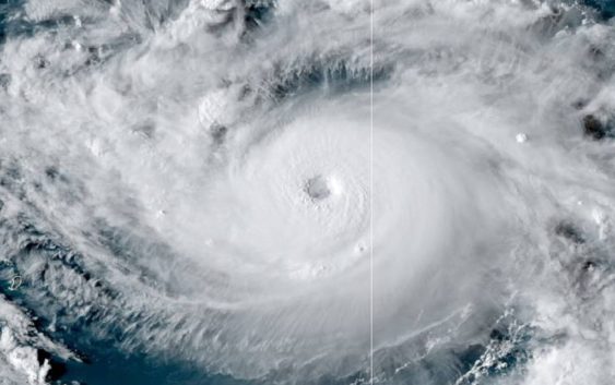
Hurricane Dorian now Category 4 storm

CHARLOTTE, N.C. — Here’s the latest on Hurricane Dorian
As of the 8 p.m. et update from the National Hurricane Center
LOCATION: 575 MI E OF WEST PALM BEACH FLORIDA
MAXIMUM SUSTAINED WINDS: 130 MPH
MOVEMENT: NW AT 10 MPH
“Dorian is now a major hurricane,” the National Hurricane Center said Friday.
Dorian is a Category 4 hurricane with sustained winds of 130 mph and is expected to make landfall in Florida as a Category 4 hurricane early next week, according to the National Hurricane Center.
The storm is moving northwest at 10 mph. It is 575 miles east of West Palm Beach, Florida.
A Hurricane Warning is in effect for Northwestern Bahamas. A Hurricane Watch is in effect for Andros Island
On this track, the core of Dorian should move over the Atlantic well north of the southeastern and central Bahamas Friday night and Saturday, be near or over the northwestern Bahamas on Sunday, and be near the Florida east coast late Monday.
North Carolina has issued a state of emergency ahead of potential impacts from Hurricane Dorian. The governor of South Carolina said he is monitoring the situation closely and may also issue a state of emergency.
Swells are likely to begin affecting the east-facing shores of the Bahamas, the Florida east coast, and the southeastern United States coast during the next few days. These swells are likely to cause life-threatening surf and rip current conditions.
Flooding will be a major concern for Florida. Rainfall rates, combined with storm surge, could result in life-threatening flash floods.
It is still not known exactly where the storm will make landfall but forecasts believe it will likely be in Florida. The uncertainty, which is commonly portrayed in the forecast track’s “cone of uncertainty,” will shrink as the storm moves closer to shore.
RELATED: 5 Things to Know About Hurricane Dorian
Panovich said everyone living along the Southeast coast should be paying attention. The track could shift.
“Residents in these areas should ensure that they have their hurricane plan in place and not focus on the exact forecast track of Dorian’s center,” according to the National Hurricane Center.
Regardless of where the storm ultimately makes landfall, heavy rain can be expected in across the Southeast next week, including in portions of North Carolina, South Carolina, Georgia, and Florida.
RELATED: Airlines offer travel waivers as Dorian reaches hurricane strength
RELATED: Person struck by lightning in Marion, numerous tress toppled during storms
RELATED: Lightning strikes kill 5, injure over 100 in eastern Europe’s Tatra Mountains
RELATED: Extensive tree damage in Statesville after severe weather
RELATED: Two rescued from flooded car during Charlotte storms