- Wildfires persist across Carolinas amid windy, dry conditions
- York County crews help battle South Carolina wildfires
- Crews battle wildfires in North and South Carolina amid dry conditions and gusty winds
- As wildfires grip South Carolina, governor warns: Burn and you’ll go to jail
- Sebastian Aho's OT goal lifts Hurricanes past Flames 2-1
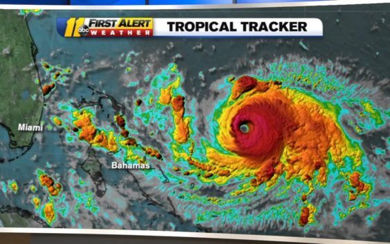
Hurricane Dorian track update: Storm strengthens to Cat 4 storm, may turn before FL landfall

Most global models now turning Dorian before a FL landfall, staying in warm water so significant weakening is unlikely. Too early to speculate impacts here in the Triangle, but looking more likely our coast will have heavy rain and some beach erosion on Thursday. pic.twitter.com/SiUG5xcOCE
— Steve Stewart (@StewartABC11) August 31, 2019
Early Saturday, Dorian was centered 470 miles east of West Palm Beach. It was moving northwest at 12 mph. Forecasters warned that its slow movement means Florida could face a prolonged wallop of wind, storm surge and torrential rain.
Millions of people in Florida, along with the state’s Walt Disney World and President Donald Trump’s Mar-a-Lago resort, are in the potential crosshairs of the hurricane. Forecasters say Dorian, which had top sustained winds of 140 mph Friday night, will threaten the Florida peninsula late Monday or early Tuesday.
RELATED: Big Weather’s hurricane emergency kit
But the National Hurricane Center in Miami cautioned that its meteorologists remain uncertain whether Dorian would make a devastating direct strike on the state’s east coast or inflict a glancing blow. Some of the more reliable computer models predicted a late turn northward that would have Dorian hug the Florida coast.
Too early for specifics, but the latest model trends for Dorian is to move along our coastline either Wednesday (GFS model) or Thursday (EURO model). The least likely, but not impossible is the red track, which would have the biggest impacts in central NC. pic.twitter.com/azF5hx42eF
— Steve Stewart (@StewartABC11) August 31, 2019
“There is hope,” Weather Underground meteorology director Jeff Masters said.
The faint hope of dodging Dorian’s fury came Friday, even as the storm ratcheted up from a menacing Category 3 hurricane to an even more dangerous Category 4. That raised fears Dorian could become the most powerful hurricane to hit Florida’s east coast in nearly 30 years.
National Hurricane Center projections showed Dorian hitting roughly near Fort Pierce, some 70 miles (113 kilometers) north of Mar-a-Lago, then running along the coastline as it moved north. But forecasters cautioned that the storm’s track remains still highly uncertain and even a small deviation could put Dorian offshore – or well inland.
Trump has declared a state of emergency in Florida and authorized the Federal Emergency Management Agency to coordinate disaster-relief efforts. He told reporters that “Mar-a-Lago can handle itself” and that he is more worried about Florida.
As Dorian closed in, Labor Day weekend plans were upended. Major airlines began allowing travelers to change their reservations without fees. The big cruise lines began rerouting their ships. Disney World and Orlando’s other resorts found themselves in the storm’s projected path.
Still, with Dorian days away and its track uncertain, Disney and other major resorts held off announcing any closings, and Florida authorities ordered no immediate mass evacuations.
“Sometimes if you evacuate too soon, you may evacuate into the path of the storm if it changes,” Gov. Ron DeSantis said.
Coastal areas of the southeastern United States could get 6 to 12 inches of rain, with 18 inches in some places, triggering life-threatening flash floods, the hurricane center said.
The hurricane center’s advisory released at 5 a.m. Saturday also warned that the “risk of strong winds and life-threatening storm surge” during the middle of next week is increasing along Georgia and South Carolina’s coasts.
Also imperiled were the Bahamas, where canned food and bottled water were disappearing quickly from shelves and the sound of hammering echoed across the islands as people boarded up their homes. Dorian was expected to hit the northwestern part of the Bahamas by Sunday with the potential for life-threatening storm surge that could raise water levels 15 feet (5 meters) above normal.
“Do not be foolish and try to brave out this hurricane,” Prime Minister Hubert Minnis said. “The price you may pay for not evacuating is your life.”
Though Dorian is growing in intensity, some of the more reliable computer models predicted a late turn northward that would have Dorian hug the coast, the National Hurricane Center said.
The faint hope came on a day in which Dorian seemed to get scarier with each forecast update, growing from a dangerous Category 3 hurricane to an even more menacing Category 4 storm. And there were fears it could prove to be the most powerful hurricane to hit Florida’s east coast in nearly 30 years.
The hurricane season typically peaks between mid-August and late October. One of the most powerful storms ever to hit the U.S. was on Labor Day 1935. The unnamed Category 5 hurricane crashed ashore along Florida’s Gulf Coast on Sept. 2. It was blamed for over 400 deaths
If Dorian makes landfall as a Category 4 storm, it would be the strongest storm to hit Florida’s Atlantic coast since Hurricane Andrew made landfall as a Category 5 storm in 1992. Andrew is blamed for 65 fatalities and more than $27 billion worth of damage.
While it is too early to know the impact Dorian will have on the Carolinas, it is never to early to prepare with the essential supplies.
Copyright © 2019 ABC11-WTVD-TV/DT. All Rights Reserved – The Associated Press contributed to this report.