- Trump approves federal assistance amid Arkansas flooding
- Weather Impact Alert: Tornado Watch issued for much of Southeast Texas until 9 p.m.
- Colorado State University predicts above-average 2025 Atlantic Hurricane Season
- South and Midwest face potentially catastrophic rains and floods while reeling from tornadoes
- Deadly 2024 hurricanes prompt WMO to retire three names
Hurricane Dorian batters Bahamas as storm eyes NC coast, U.S.

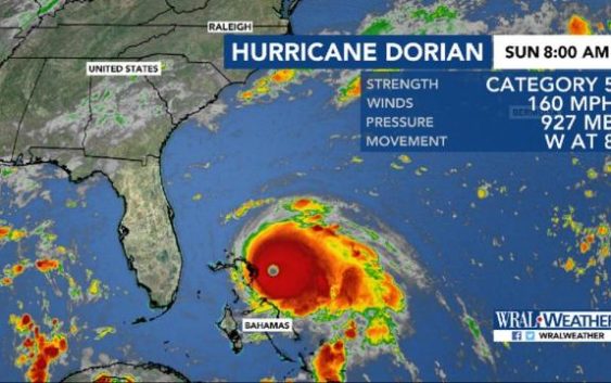
Raleigh, N.C. — Dorian made landfall in the Bahamas on Sunday at 12:45 p.m. and is already creating strong rip currents off North Carolina’s coast, but it shouldn’t bring heavy rain and winds to North Carolina until Wednesday or Thursday.
From Florida to North Carolina, residents and government officials have been preparing for possible impacts of Dorian for days, even as the official forecast has the center of the storm staying offshore.
The Category 5 hurricane’s nearly unprecedented strength — the 185 mph (295 kph) winds made it the second strongest storm in the Atlantic Ocean since 1950 — has people aware that even a tiny error in the forecast could be catastrophic.
“We may not do anything. But we have to be ready for it,” said Neil Baxley, commander of emergency services in coastal South Carolina’s Beaufort County. “We are deep in the error cone.”‘
The gas lines and people queued up with carts outside grocery stores weren’t seen Sunday along the southeast U.S. coast.
Instead, people were watching and waiting to see the destruction from the northern Bahamas, where Dorian made landfall on the Abaco Islands.
“I’m thanking God now that it has turned a little more to the east. But that’s a forecast. We never know,” said Kevin Browning, who was at the Vero Beach Home Depot looking for supplies after putting up his hurricane shutters Friday. “I feel for the Bahamas and I’m praying for them.”
Some evacuations have already begun in Florida, where the governor suspended tolls. Father up the coast, South Carolina Gov. Henry McMaster held a short news conference where he wouldn’t say when he might make a decision on evacuations and the main goal seemed to be to promise officials were on top of things.
South Carolina has ordered evacuations in each of the past three hurricane seasons and with just one storm making landfall during that time — Michael in 2016 — there is storm weariness in the state.
McMaster asked residents to stay tuned.
“We don’t have a solid prediction as to where it might turn, where it might not turn when it will get here. But we assure you we have the best minds and the most experienced and talented people working around the clock,” the governor said.
The well-organized, tight storm is expected to move past the Bahamas slowly, dumping heavy rain there Sunday and Monday. A storm surge of up to 23 feet above normal tide levels was expected, and the National Hurricane Center called the situation life-threatening.
“Dorian could become almost stationary in the Bahamas,” WRAL meteorologist Peta Sheerwood said. A slow-moving storm is a dangerous one, and Dorian is expected to remain Category 5 for several hours before it weakens to Category 4 by Monday.
In a press conference on Sunday, Gov. Roy Cooper asked North Carolinians to be prepared.
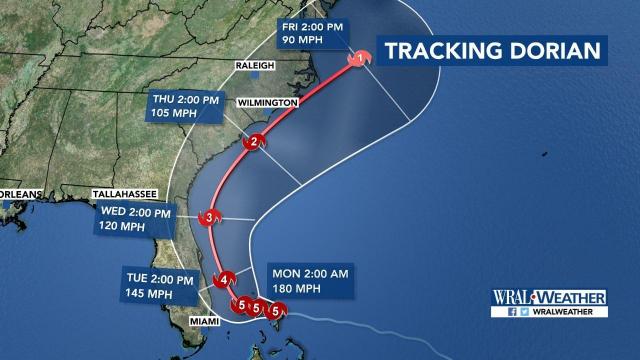
As the steering ridge breaks down, it will likely begin to steer Dorian north early Monday. A direct Florida landfall appears less likely but impacts are still possible.
By Tuesday, models show Dorian moving north in the Atlantic, parallel to the coastline. According to Sheerwood, Dorian could weaken to a Category 3 storm by Wednesday as it loses intensity.
By Wednesday night or Thursday, Dorian is expected to affect central North Carolina and the coast. At that time, it could impact South Carolina and North Carolina, dropping heavy rain along the the coast and bringing strong winds.
One line in a scatter model indicates that Dorian could make landfall in North Carolina, while most tracks show the storm moving off into the Atlantic Ocean.
The coast, the Triangle and Charlotte are all within the cone, meaning landfall is possible there. “Since the cone includes the coast, and Raleigh, we have to keep a close eye on this,” Sheerwood said.
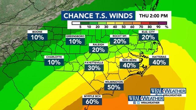
Depending on the storm’s path, central North Carolina could see tropical storm force winds around 45 or 50 mph by 2 p.m. Thursday. North Carolina’s coast could experience even stronger winds of 70 to 90 mph.
Sheerwood said rainfall totals “look impressive,” with some coastal areas expected to get as much as 10 inches. On Sunday, there was already a rip current threat for the coast, so Labor Day beachgoers should use caution if they swim in the ocean.
The University of North Carolina Wilmington posted a notice on Facebook, asking students to stay out of the ocean.
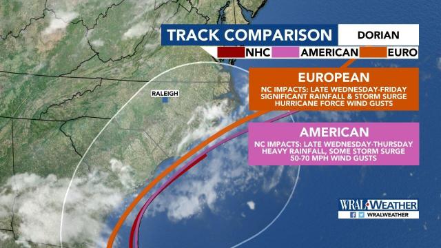
Both the American and European forecast models keep Dorian off the Florida coast without making direct landfall in the state. The American model shows Dorian at the southern tip of the North Carolina coast, moving through the entire coastline through Thursday afternoon.
The European model shows a slower track, putting Dorian at the southern tip of the North Carolina coast Thursday afternoon and moving out Friday afternoon.
Barry Porter, regional director of the Red Cross for eastern North Carolina, said he thought when the storm was developing that it might follow the same path as Hurricane Matthew in 2016.
He advised North Carolina residents to pay attention to forecast updates and prepare now for the affects of Dorian.
“Be ready, and take steps now,” he said. “Don’t wait till 24 hours. You have four, five days’ notice. Take effective steps today.”
Gov. Roy Cooper is expected to hold a news briefing at the State Emergency Operations Center in Raleigh at 1:30 p.m. on Sunday.


