- Cast of Scandal reunites to show support for western North Carolina after Hurricane Helene
- Tropical Storm Sara threatens to bring flash floods and mudslides to Central America
- Hurricane-stricken Tampa Bay Rays to play 2025 season at Yankees' spring training field in Tampa
- Utah scores 3 goals in 2 1/2 minutes in 3rd, Vejmelka has 49 saves in 4-1 win over Hurricanes
- Driver dies after crashing off hurricane-damaged highway in North Carolina
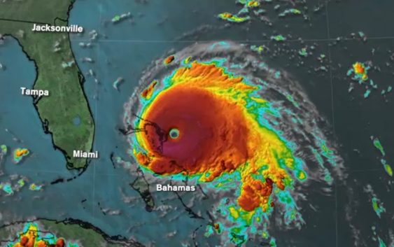
Hurricane Dorian intensifies to 'catastrophic' Category 5 storm as it lashes Bahamas

The U.S. National Hurricane Center is describing the pounding the northwest Bahamas as a “life-threatening situation” and urged residents not to venture out into Dorian’s well-defined eye should it pass overhead.
At 3 p.m. EDT Sunday, Dorian had top sustained winds of 185 mph with gusts topping 220 mph. The Miami-based hurricane center said it expects storm surge of 18 to 23 feet above normal in the hardest-hit areas. It says there also will be even higher battering waves.
The center said Dorian tied for the strongest Atlantic hurricane landfall on record with the 1935 Labor Day hurricane.
Forecasters warn that Dorian is moving so slowly westward — just 7 mph — that those in the affected areas of the Bahamas will continue to receive a pounding from Dorian’s wind and surging seas for several more hours
WATCH: Bahamas resident shows, describes conditions as Dorian pounds island nation
Authorities in the Bahamas are saying they are receiving preliminary reports of heavy damages in areas being pounded by Hurricane Dorian.
Joy Jibrilu, director-general of the Bahamas’ Ministry of Tourism & Aviation, has told reporters there is a huge amount of damage to property and infrastructure from the hurricane crossing the northwest part of the island archipelago. She adds “It’s devastating” but cautions that so far there is “luckily no loss of life reported.”
Life-threatening storm surge and very heavy rainfall is expected.
A tropical storm warning was issued between Deerfield Beach up to Sebastian Inlet on southern Florida’s east coast, while a tropical storm watch was issued between Deerfield Beach down to Golden Beach.
RELATED: What do hurricane categories mean?
The National Hurricane Center’s rainfall estimates for the northwestern Bahamas were upped to 12 to 24 inches, with isolated incidents of 30 inches, while estimates for the coastal Carolinas were between 5 to 10 inches of rain, with isolated cases of 15 inches.
Hurricane Dorian is still a CAT 4 storm with winds gusting to 185mph. The official track hasn’t changed much since last night…we still expect tropical storm conditions in North Carolina by Thursday. pic.twitter.com/GDKP0Vukmn
— Steve Stewart (@StewartABC11) September 1, 2019
Millions from Florida to the Carolinas are keeping a wary eye on Dorian amid indications it would veer sharply northeastward after passing the Bahamas and track up the U.S. Southeast seaboard. But authorities warned even if its core did not make U.S. landfall and stayed offshore, the potent Category 4 storm would likely hammer U.S. coastal areas with powerful winds and heavy surf.
The cities of Brunswick, Georgia; Charleston, South Carolina; and Wilmington, North Carolina, could all see more than six inches of rain, according to the latest forecast.
TIMING AND PATH
As of now, we can expect the breeze to pick up out of the northeast Wednesday. Some of the outer rain bands of Hurricane Dorian may already be moving into the southern and eastern parts of North Carolina.
It will likely be breezy to windy across central North Carolina on Wednesday night into Thursday, with more showers and a thunderstorm likely. The steadiest and heaviest rain will be to the east and southeast of the Triangle.
The main thing to point out during this time is that the impacts will be greatest as far as heavy rain and stronger winds go, the farther east and southeast you are from Raleigh. We are still not ruling out a landfall somewhere along the North Carolina coast.
Dorian will begin to increase in forward speed to the northeast Thursday and Friday. While the impacts and track and can still vary between now and then, it is highly likely that at least coastal North Carolina will have a period of heavy rain, strong gusty winds and coastal flooding/beach erosion Wednesday night into Thursday.
PREPARE FOR THE STORM
While it is too early to know the impact Dorian will have, it is never to early to prepare with the essential supplies.
What to know about generators before a power outage
What happens to your home in hurricane-force winds?
Foods to stock up on before a storm hits
Copyright © 2019 ABC11-WTVD-TV/DT. All Rights Reserved – The Associated Press contributed to this report.