- One set of evacuation orders lifted in Caldwell County after wildfire contained
- 'We gutted every building' | Chimney Rock rebuilding after Hurricane Helene
- 'We gutted every building' | Chimney Rock rebuilding after Hurricane Helene
- Debris from Hurricane Helene provides fuel, complicates containment for spring wildfires
- David & Nicole Tepper increase Hurricane Helene relief commitment to $750k
Hurricane Dorian intensifies to dangerous Cat. 5 storm, expected to affect North Carolina by midweek
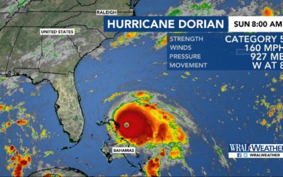
Raleigh, N.C. — An 8 a.m. update from the National Hurricane Center identifies Hurricane Dorian as a Category 5 storm. Dorian will close in on the Bahamas on Sunday, but it shouldn’t impact North Carolina until Wednesday or Thursday, according to an update from the National Hurricane Center.
An 8 a.m. update shows that Dorian now has windspeeds up to 160 mph. It is moving west at 8 mph and is 653 miles southeast of Raleigh. The well-organized, tight storm is expected to move into the Bahamas slowly, dumping heavy rain there Sunday and Monday.
As the steering ridge breaks down, it will likely begin to steer Dorian north early Monday. A direct Florida landfall appears less likely but impacts are still possible.
By Tuesday, models show Dorian moving north along the coast. According to WRAL meteorologist Peta Sheerwood, Dorian could weaken to a Category 3 storm by Wednesday as it loses intensity.

By Thursday afternoon or Friday, Dorian is expected to weaken to a Category 1 hurricane. At that time, it could impact South Carolina and North Carolina, dropping heavy rain along the the coast and bringing strong winds.
One line in a scatter model indicates that Dorian could make landfall in North Carolina, while most tracks show the storm moving off into the Atlantic Ocean.
“Since the cone includes the coast, and Raleigh, we have to keep a close eye on this,” Sheerwood said.

Depending on the storm’s path, central North Carolina could see tropical storm force winds around 45 or 50 mph by 2 p.m. Thursday. North Carolina’s coast could experience even stronger winds of 70 to 80 mph.
Sheerwood said rainfall totals “look impressive,” with some coastal areas expected to get as much as 10 inches. On Sunday, there was already a rip current threat for the coast, so Labor Day beachgoers should use caution if they swim in the ocean.
Both the American and European forecast models keep Dorian off the Florida coast without making direct landfall in the state. The American model shows Dorian at the southern tip of the North Carolina coast, moving through the entire coastline through Thursday afternoon.
The European model shows a slower track, putting Dorian at the southern tip of the North Carolina coast Thursday afternoon and moving out Friday afternoon.

Barry Porter, regional director of the Red Cross for eastern North Carolina, said he thought when the storm was developing that it might follow the same path as Hurricane Matthew in 2016.
He advised North Carolina residents to pay attention to forecast updates and prepare now for the affects of Dorian.
“Be ready, and take steps now,” he said. “Don’t wait till 24 hours. You have four, five days’ notice. Take effective steps today.”