- Fake job seekers are flooding the market, thanks to AI
- One set of evacuation orders lifted in Caldwell County after wildfire contained
- 'We gutted every building' | Chimney Rock rebuilding after Hurricane Helene
- 'We gutted every building' | Chimney Rock rebuilding after Hurricane Helene
- Debris from Hurricane Helene provides fuel, complicates containment for spring wildfires
Hurricane Dorian intensifies to potentially catastrophic Category 5 storm as it nears Bahamas

Just before 8 a.m. ET Sunday, Dorian became a potentially catastrophic Category 5 storm with maximum sustained winds of 160 mph. It was around 35 miles east of Great Abaco Island in the Bahamas moving west at 8 mph.
Life-threatening storm surge and very heavy rainfall is expected.
A tropical storm warning was issued between Deerfield Beach up to Sebastian Inlet on southern Florida’s east coast, while a tropical storm watch was issued between Deerfield Beach down to Golden Beach.
The National Hurricane Center’s rainfall estimates for the northwestern Bahamas were upped to 12 to 24 inches, with isolated incidents of 30 inches, while estimates for the coastal Carolinas were between 5 to 10 inches of rain, with isolated cases of 15 inches.
Hurricane Dorian is still a CAT 4 storm with winds gusting to 185mph. The official track hasn’t changed much since last night…we still expect tropical storm conditions in North Carolina by Thursday. pic.twitter.com/GDKP0Vukmn
— Steve Stewart (@StewartABC11) September 1, 2019
Millions from Florida to the Carolinas are keeping a wary eye on Dorian amid indications it would veer sharply northeastward after passing the Bahamas and track up the U.S. Southeast seaboard. But authorities warned even if its core did not make U.S. landfall and stayed offshore, the potent Category 4 storm would likely hammer U.S. coastal areas with powerful winds and heavy surf.
The cities of Brunswick, Georgia; Charleston, South Carolina; and Wilmington, North Carolina, could all see more than six inches of rain, according to the latest forecast.
TIMING AND PATH
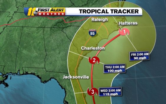
As of now, we can expect the breeze to pick up out of the northeast Wednesday. Some of the outer rain bands of Hurricane Dorian may already be moving into the southern and eastern parts of North Carolina.
It will likely be breezy to windy across central North Carolina Wednesday night into Thursday, with more showers and a thunderstorm likely. The steadiest and heaviest rain will be to the east and southeast of the Triangle.
The main thing to point out during this time is that the impacts will be greatest as far as heavy rain and stronger winds go, the farther east and southeast you are from Raleigh. We are still not ruling out a landfall somewhere along the North Carolina coast.
Dorian will begin to increase in forward speed to the northeast Thursday and Friday. While the impacts and track and can still vary between now and then, it is highly likely that at least coastal North Carolina will have a period of heavy rain, strong gusty winds and coastal flooding/beach erosion Wednesday night into Thursday.
While it is too early to know the impact Dorian will have, it is never to early to prepare with the essential supplies.
Copyright © 2019 ABC11-WTVD-TV/DT. All Rights Reserved – The Associated Press contributed to this report.