- Seven months after Hurricane Helene, Chimney Rock rebuilds with resilience
- Wildfire in New Jersey Pine Barrens expected to grow before it’s contained, officials say
- Storm damage forces recovery efforts in Lancaster, Chester counties
- Evacuation orders lifted as fast-moving New Jersey wildfire burns
- Heartbreak for NC resident as wildfire reduces lifetime home to ashes
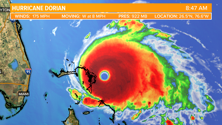
Hurricane Dorian intensifies to strong category 5 hurricane

FLORIDA, USA — As of 8:30 a.m. Sunday, Hurricane Dorian is a category 5 storm with maximum sustained winds of 175 mph. The new forecast has shifted it more to the northeast; regardless, Florida and the East Coast need to prepare for landfall.

Hurricane Dorian
Andrew Wilson
The National Hurricane Center stated the storm has gusts more than 200 mph and a storm surge may be experienced in the Bahamas at a height between 15 to 20 feet.
Hurricane Warnings and Watches are in place for the Bahamas, but too soon to issue watches for Florida because Dorian is moving slow to the west-northwest.


Hurricane Dorian
Andrew Wilson
Here’s the difference in tropical warnings and watches:


KENS
Impacts include high wind gusts, heavy rain, flash flooding, and dangerous storm surge.
The Air Force Reserve 53d Weather Reconnaissance Squadron (Hurricane Hunters) and NOAA Corps have been flying the storm, gathering data to perfect the model forecast for days and they are expected to continue flying the storm up until landfall.
RELATED:
First Alert Forecast: Rain chances and slightly cooler weather fill the forecast
Hurricane Hunters make history with first all-female three-pilot crew
The storm is forecast to dump a high amount of rain across Florida and into other parts of the southeast over the next week. If you have friends or family living in Florida, give them a call to make sure they understand the forecast and what the storm’s impacts may be.
The storm isn’t expected to cause any impacts to Texas, but we will continue to keep you updated in case things change.
WATCH: A guided tour of the new KENS 5 app!
PEOPLE ARE ALSO READING:
SAPD: Standoff in Castle Hills apartment complex
Texas teams with Bumble to crack down on ‘cyber flashing’
Lila Cockrell, first female mayor of San Antonio, passes away at 97