- National memorial to honor NC firefighter who died on duty during Hurricane Helene
- Gov. Josh Stein extends State of Emergency for western NC wildfires
- Governor Stein extends state of emergency for NC wildfire threat
- Governor Stein extends emergency in 34 NC counties amid wildfire threat
- Texans can buy emergency preparation supplies tax-free April 26-28 ahead of severe weather season
Hurricane Dorian now a 'catastrophic' Category 5 storm

ST. PETERSBURG, Fla. — There’s no doubt: Hurricane Dorian is a monster storm, and it’s looking all the more likely parts of the northern Bahamas will be devastated.
Dorian has strengthened to become the first Category 5 storm in the Atlantic basin — including the Gulf of Mexico and the Caribbean Sea — since Michael in 2018. Irma and Maria in 2017 also intensified into Category 5 hurricanes.
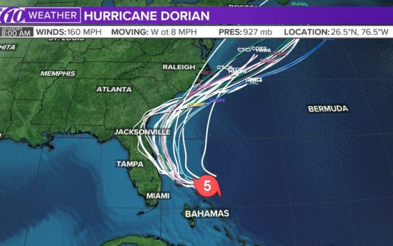
The most reliable weather computer models have been consistent during the past day in keeping the powerful storm just off the Florida coast and away from landfall. These models, however, are not forecasts — and they tend to change with every update.
In fact, after an eastward shift during the day Saturday, some models again include parts of Florida’s east coast for significant impacts or a potential landfall.
Dorian is an extremely dangerous, 160-mph Category 5 storm as of the National Hurricane Center’s latest advisory. It is about 35 miles east of Great Abaco Island in the Bahamas, moving west at 8 mph.
The minimum central pressure, an indication of the storm’s strength, is 927 mb. Typically, lower pressures correlate with higher wind speed.
LIVE BLOG: The latest, need-to-know information on Hurricane Dorian
The following watches and warnings are in effect:
- Hurricane warning: Northwestern Bahamas, excluding Andros Island
- Hurricane watch: Andros Islands
- Tropical storm warning: North of Deerfield Beach to Sebastian Inlet, Florida.
- Tropical storm watch: North of Golden Beach to Deerfield Beach.
RELATED: What’s the difference between a hurricane watch and a warning?
Prolonged life-threatening storm surge and devastating hurricane-force winds are expected Sunday through early Monday for the northwest Bahamas.
Hurricane Dorian is moving westward, but a shift to the north is expected during the next several days. Although the official forecast track by the National Hurricane Center has shifted more so to the east, there remains some uncertainty in exactly when and just where that turn to the north will occur.
10Weather and National Hurricane Center meteorologists expect the core of Dorian to continue a churn toward the northwestern Bahamas on Sunday and approach Florida’s east coast on Monday.
From there, the latest data suggests Dorian will make that eventual slow turn to the north. This is a positive forecast for the Tampa Bay region but one of most concern for Florida’s east coast because a slow, powerful storm that rides the coastline is likely to bring more prolonged and significant impacts.
Again, stay tuned to the latest forecast as Dorian’s track and intensity become more certain.
►Track the weather and get severe alerts when they happen: Download the 10 News app now.
►Stay informed with all tropical weather: Check out our must-have interactive Hurricane Headquarters guide here.
Spaghetti models
Each line represents a computer model’s best “guess” of where the center of the storm will go. Together, they look like spaghetti noodles. Remember, impacts from a tropical system can and do occur miles away from the center.
App users — tap here if you cannot see the image below.
Tropical track
This is the latest “cone of uncertainty,” which shows an area where the center of the storm could go, when and how strong it might be at the given time.
App users — tap here if you cannot see the image below.

Satellite and radar
The latest satellite and radar image for the Gulf of Mexico, Caribbean Sea and Atlantic Ocean.
App users — tap here if you cannot see the image below.
Watches and warnings
What’s a watch? What’s a warning? Here are the official alerts that can be issued for your area and what you should do.
App users — tap here if you cannot see the image below.

