- South Carolina's governor declares State of Emergency as massive wildfire grows to 1,600 acres
- Staying weather alert: How to find your safe place during severe weather
- Wildfires persist across Carolinas amid windy, dry conditions
- York County crews help battle South Carolina wildfires
- Crews battle wildfires in North and South Carolina amid dry conditions and gusty winds
Before-and-after photos show how badly Hurricane Dorian flooded the Bahamas
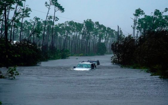
The Bahamas felt the full power of Hurricane Dorian when the storm slammed into the islands Sunday. With 185 mph winds at landfall, the storm resulted in massive damage.
What followed might be just as dangerous, more than a day of torrential downpours and a storm surge that lead to flooding throughout the islands.
As of now, at least five people are dead as a result of the storm, and it will be a while before the damage can be totaled.
The videos out of the Bahamas have shown the devastation up close, but using Google satellite photos and images from a commercial satellite monitoring company, we are starting to the scale of the destruction.
If you can’t see the before and after satellite images in the tweet below, click here.
The most recent image was taken at 11:45 a.m., so it is far from what the island will look like once Dorian and its surge finally clear the area.
What it does show is how high the water was during the dangerous flooding that will continue to endanger residents.
What other people are reading right now:
►Make it easy to keep up-to-date with more stories like this. Download the 10News app now.
Have a news tip? Email desk@wtsp.com, or visit our Facebook page or Twitter feed.