- California governor asks Congress for nearly $40 billion for Los Angeles wildfire relief
- North Buncombe High School students lead recovery efforts for NC farmers post-Hurricane Helene
- LA mayor dismisses fire chief over response to most destructive wildfire in city history last month
- Some in Hurricane Helene-ravaged North Carolina embrace Pres. Trump’s push to abolish FEMA
- Homes destroyed: Western NC families battling insurance disputes after Hurricane Helene
Hurricane Dorian, Again Category 2, Is Hitting Carolinas With ‘Serious’ Strength
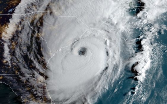
Hurricane Dorian is edging close to the southeastern coast, bringing dangerous flooding to South Carolina. The storm is seen here at 8 a.m. ET Thursday.
Hurricane Dorian is churning just off the coast of the Carolinas, flooding areas along the shore of both states with a storm surge that could measure up to 5-8 feet. The storm, which regained Category 3 intensity overnight, now threatens heavy rainfall up to 15 inches and flash flooding. It has also spun off apparent tornadoes.
As of 11 a.m. ET, Dorian’s maximum sustained winds were at 110 mph — the upper limit for a Category 2 storm.
“This is a life-threatening situation. Persons located within these areas should take all necessary actions to protect life and property from rising water and the potential for other dangerous conditions,” the National Hurricane Center warns in its advisory Thursday morning.
For the time being, Dorian’s eyewall continues to whip the waters some 50 miles east-southeast of Charleston, S.C., slowly following a path northwest while thrashing the Carolinas with its outer rain bands. Landfall remains possible Thursday — and if Dorian strengthens a bit and its eye reaches the coast, it could be just the fifth hurricane of Category 3 or higher to hit South or North Carolina since 1950, according to Colorado State University meteorologist Philip Klotzbach.
The center of #HurricaneDorian, seen here by NOAA’s #GOESEast, is moving close to the #SouthCarolina coast this morning. The Category 3 storm is already producing very heavy rainfall along the #NC and #SC coasts. Follow the storm via our hurricane tracker: https://t.co/dhw0zOk2i6 pic.twitter.com/cuaB7aWWjJ
— NOAA Satellites (@NOAASatellites) September 5, 2019
Even if Dorian does not come ashore, its proximity and steady strength promises a dangerous day for residents in the Southeast, where more than 1 million people are under mandatory evacuation orders.
“It is serious, and it can be deadly,” North Carolina Gov. Roy Cooper told a news conference Thursday morning. “The message this morning is this: Get to safety and stay there. Don’t let your guard down. This won’t be a brush-by. Whether it comes ashore or not, the eye of the storm will be close enough to cause extensive damage in North Carolina.”
Cooper’s constituents need not look far to find what Dorian has been capable of. In the Bahamas, which Dorian battered for more than two days, authorities say at least 20 people have died, and they fear that death toll could rise significantly as rescue and recovery efforts unfold on the Caribbean island chain.
Images from the area reveal houses leveled, docks washed away and entire neighborhoods reduced to landscapes of rubble and ruin.
“We don’t have a full scope of the damage,” Vice Adm. Scott Buschman, who oversees U.S. Coast Guard operations in the Atlantic, tells NPR’s Morning Edition. “But the areas I flew over yesterday — and I haven’t flown over a lot of storms — I saw, if not the most significant damage and destruction, probably the most significant damage and destruction I’ve ever seen.”
Now, South Carolina and North Carolina are facing a slightly diminished— but still dangerous — Dorian. According to the National Hurricane Center, the storm is creating conditions that can also spawn tornadoes in the storm-lashed regions. Videos recorded Thursday morning in North Myrtle Beach, S.C., and Pender County, N.C., appear to show tornadoes taking shape amid the whipping winds.
Video of a tornado passing near Pender County Fire Station 18 along Highway 17 near Sidbury Rd. Video courtesty of Station 18. Time was around 6:55-7:00 AM EDT Thursday Sept 5, 2019 pic.twitter.com/RRFhZuL47l
— NWS Wilmington NC (@NWSWilmingtonNC) September 5, 2019
The Carolinas are not the only regions currently feeling the effects of Dorian, either, as its outer bands are stretching across much of the U.S. Atlantic seaboard. And as far north as the Canadian province of Newfoundland and Labrador, authorities have warned of the possibility of tropical-storm-force winds and “rough and pounding surf” related to the hurricane.
Copyright 2019 NPR. To see more, visit https://www.npr.org.9(MDAyMTgwNzc5MDEyMjQ4ODE4MjMyYTExMA001))