- South Carolina's governor declares State of Emergency as massive wildfire grows to 1,600 acres
- Staying weather alert: How to find your safe place during severe weather
- Wildfires persist across Carolinas amid windy, dry conditions
- York County crews help battle South Carolina wildfires
- Crews battle wildfires in North and South Carolina amid dry conditions and gusty winds
Tropical Storm Humberto nearing hurricane strength
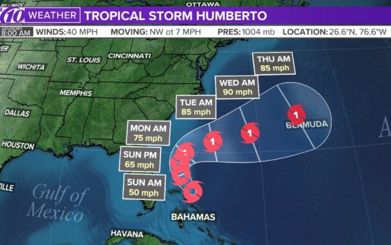
ST. PETERSBURG, Fla. — Tropical Depression 9 strengthened Friday night into Tropical Storm Humberto.
The National Hurricane Center’s latest storm track keeps the storm offshore of Florida.
The National Hurricane Center says global weather models suggest the cyclone will strengthen into a hurricane by Sunday. But, by then, it’s expected to have shifted well over the Atlantic Ocean — southeast of the coast of the Carolinas.
The Friday night advisory from the National Hurricane Center took all of the Tampa Bay area out of the cone of uncertainty.
RELATED: NOAA scientist: agency likely broke science integrity rules in chastising Alabama office
RELATED: NOAA criticized for defending Trump’s Hurricane Dorian claim
As of the latest advisory, the system was about 180 miles north-northwest of Great Abaco Island. It has maximum sustained winds of 65 mph and is moving north at 7 mph.
There are no tropical storm watches or warnings in effect.
10Weather Meteorologist Grant Gilmore says this particular disturbance could bring heavy rain and gusty winds to parts of the Bahamas. That could be a problem for parts of the islands affected by Hurricane Dorian.
►Stay informed with all tropical weather: Check out our must-have interactive Hurricane Headquarters guide here.
WATCH: 10News is your Hurricane Headquarters
FREE 10NEWS APP:


►Stay In the Know! Sign up now for the Brightside Blend Newsletter