- South and Midwest face potentially catastrophic rains and floods while reeling from tornadoes
- Deadly 2024 hurricanes prompt WMO to retire three names
- Body recovered in North Carolina identified as East TN man who has been missing ever since Hurricane Helene
- Report: Coastal flooding could threaten 1.4 million homes by midcentury
- Caught on camera | Tornado touches down in Missouri
Heavy rain and flash flooding threaten the Texas coast Tuesday night
-
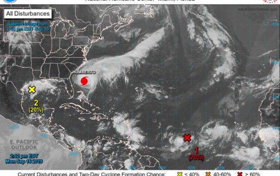
The National Hurricane Center predicts heavy rain along the Gulf Coast starting Tuesday night or Wednesday as an area of low pressure develops.
The National Hurricane Center predicts heavy rain along the Gulf Coast starting Tuesday night or Wednesday as an area of low pressure develops.
Photo: NOAA
The National Hurricane Center predicts heavy rain along the Gulf Coast starting Tuesday night or Wednesday as an area of low pressure develops.
The National Hurricane Center predicts heavy rain along the Gulf Coast starting Tuesday night or Wednesday as an area of low pressure develops.
Photo: NOAA
Heavy rainfall is headed towards the Houston area as early as Tuesday night, according to the NOAA National Hurricane Center.
Disorganized showers and thunderstorms are currently building in the Gulf of Mexico and are expected to threaten the central and upper Texas coastal areas.
STAY INFORMED: Get all the news you know to start your day, delivered to your inbox
Water levels may rise in small streams and bayous, and street flooding is possible with this storm, forecasters said.
Another disturbance in the Atlantic has a 70 percent chance of developing into a stronger storm, according to the National Hurricane Center. But that disturbance is expected to move northwest toward the East Coast.