- Austin adopts new map that greatly expands area at risk of wildfire
- CenterPoint Energy accelerates infrastructure improvements ahead of hurricane season
- Carolina Hurricanes playoff tickets go on sale Thursday
- Ask the Meteorologist: Why do tornadoes target Tornado Alley, Dixie Alley?
- Nonprofit closes distribution site that aided thousands after Hurricane Helene
Sudden Tropical Storm Imelda Poses Serious Flooding Threat This Week

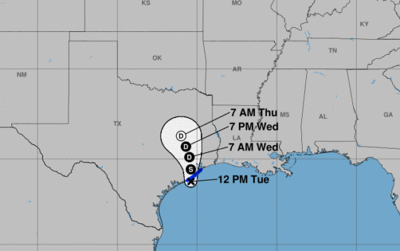
Within the span of just a few hours Tuesday, a tropical disturbance in the western Gulf of Mexico spun up into Tropical Storm Imelda and, just as quickly, moved on shore near Freeport. Fortunately, because the storm was so close to land, it didn’t have a chance to intensify into a hurricane, but it will never the less drop copious amounts of rain on much of east and southeast Texas between now and Friday.
Imelda is expected to move generally north roughly along a line formed by Interstate 45. High pressure over the Tennessee Valley will slow the storm to a crawl as it moves gradually out of the area. That means, with nearly three times the amount of moisture in the atmosphere as normal, the entire area is expected to get 3 to 6 inches of rain with many more spots getting as much as 20 inches.
The latest forecast models that ran at noon on Tuesday are calling for bullseyes of 17 to 22 inches of rain in northern Harris County over the next 72 hours with most of central Houston getting anywhere from 8 to 12 inches.
Much of that rainfall is expected Wednesday into Thursday and while it is certainly a ton of rain, this is not a Hurricane Harvey or Tropical Storm Allison event. It could rival the Memorial Day floods of 2015. The guys at Space City Weather have ranked this as a Stage 2 or Stage 3 event on their extremely handy flooding scale.
The good news is most of Houston is prepared for this type of rain event. Ten inches of rain spread over three days is a lot, but not anything we cannot handle. The biggest issue for an event like this will be travel. With rains of at least 5 or 6 inches across the area, low lying spots like feeder roads and underpasses could become blocked. Traffic is likely to be a nightmare, particularly during rush hour on Wednesday evening and Thursday morning.
By Friday, most of the rain will have moved well to our north and we’ll begin to dry out.