- 3 dead, flash floods overwhelm South Texas, with some areas receiving more than 12 inches of rain
- Flash floods overwhelm South Texas, with some communities receiving more than 12 inches of rain
- Flash floods overwhelm South Texas, with some communities receiving more than 12 inches of rain
- 3 dead, more than 200 rescued in South Texas after severe storms cause flooding
- Wildfires threaten air quality across Carolinas
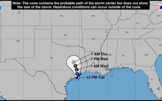
Tropical depression 11 forms in Gulf; Flash flood watch goes into effect at 1 p.m.

HOUSTON — The system in the Gulf is now a tropical depression with 35 mph winds. It’s moving north at 7 mph.
Heavy rain has already been observed in many coastal areas Tuesday morning and it’s likely to continue area wide as we head into the afternoon hours today as well as over the next couple of days.
DOWNLOAD OUR NEW APP: Stay weather aware and get the latest alerts, tap here
A very real flash flood possibility exists across southeast Texas and southwest Louisiana.
While it’s impossible to tell you what areas will get hammered and which ones won’t, it stands to reason that everybody is likely to see tropical downpours that could cause flooding of low-lying areas.
A Flash Flood Watch has been issued for Brazoria, Chambers, Fort Bend, Harris, Liberty, Matagorda, Galveston and Wharton counties from 1 p.m. Tuesday until Wednesday afternoon. This is likely to be extended into Thursday.
Computer models continue to increase the amount of rain we could see over the next 72 hours and it’s concerning for sure for a couple of reasons.
First, while the ground is dry it’s also like concrete. If we experience rain rates as high as 2 to 3 inches per hour, we’ll see much of that turn into run off that could quickly flood some areas.
Second, a lot of runoff will likely cause bayous, streams and rivers to rise. If and only if the blockbuster amounts shown in the models come to fruition, we could see swelling of the bayous.
RELATED: How the City of Houston is preparing for the rainy week ahead
RELATED: 5 ways to prepare for potential flooding
RELATED: Gov. Abbott places several state resources on standby in front of possible flooding
Here’s a timeline of what you can expect
Tuesday Morning
Heaviest rain on the Galveston and upper Texas coast. Flood threat stays low. Watch for minor flooding in low spots at times of high tide near the coast.
Tuesday Afternoon
Scattered tropical downpours move inland across southeast Texas and Houston. Storms should be moving quickly but may cause some isolated street flooding. Flood threat still low.
Tuesday night and Wednesday morning
Flash flooding becomes a larger threat as the disturbance moves onshore. Rainfall rates of 2 to 4 inches per hour and the threat for ‘training’ increases. Flood threat moderate.
Wednesday night and Thursday morning
At this point the ground across Houston and southeast Texas will become saturated. Any heavy downpours that develop and train across the area will quickly spark the threat for flash flooding on roads, creeks and bayous. Rivers will have to be closely monitored as well. Flash flood threat high.
Thursday afternoon and evening
Some computer models have the system and the rain moving north out of the Houston area Thursday evening. Others have it lingering through Thursday evening until finally exiting on Friday. For now I’ll leave the flash flood threat elevated through Thursday night.
If you live near a low lying area or spot that is prone to flooding stay close to the weather forecast and monitor the radar. Be sure to watch the weather at least once a day on KHOU 11 News and stay weather aware with us as we enter the busy time of hurricane season.
WEATHER RADAR: Track rain & storms across Texas
Five ways to prepare for flooding
There are five things you can do right now to make sure you’re ready.
1. Register for AlertHouston
Alert Houston is how the City of Houston sends out critical emergency information. It will alert you via email, text, phone call, or push alert. You can get geo-targeted warnings at your location. You can also register up to five addresses.
2. Register for Harris County’s Flood Warning System
FWS monitors rainfall at more than 250 locations along bayous, creeks, and rivers. It will alert users in real time as water levels rise through email and/or text message.
3. Look at Houston’s Flood Prone Map
The City of Houston Office of Emergency Management partnered with Houston Public Works and TxDOT to identify over 100 flood prone roadways. Drivers should check the map before rain events.
4. Download the Transtar App
The Transtar app allows you to monitor road conditions in real time. It also shows regional alerts and active incidents on an interactive map. (Android users, tap here.)
5. Pay attention to meteorologists
Visit our KHOU Weather page.