- One year after devastating Panhandle wildfires, Canadian resident reflects on the work of rebuilding
- Hays County judge says software glitch caused some communication issues during wildfires
- FEMA deadline for Hurricane Helene recovery aid to governments, nonprofits extended
- Sellers and Rantanen are among the NHL trade deadline winners. Hurricanes and Boeser are some losers
- Hurricane forecasters express concern over NOAA job cuts impact
Tornado watch in effect for western counties
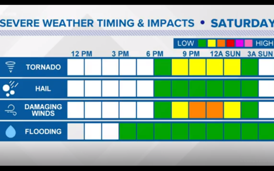
CHARLOTTE, N.C. — The First Warn Storm Team is tracking a severe weather threat this evening that could bring damaging wind and an isolated tornado to parts of Charlotte and the Carolinas.
A tornado watch is in effect until midnight for western counties including Avery, Burke, Caldwell, and Cleveland.
The system has been tracking eastward across the southern half of the country since early Friday, where it brought tornadoes and damaging conditions to several states.
This morning, the line is moving through portions of Alabama, Mississippi, Georgia, Kentucky, and Tennessee. Later this evening is the main event for us and we do have the right fuel in place for some severe storms.
First Warn Chief Meteorologist Brad Panovich said there is a “low risk” for seeing severe weather but that the risk of seeing damaging wind or a tornado is “non-zero,” or in other words: existent but low.
“The jet stream has produced a big cut-off low pressure system – as well as a lot of wind,” Panovich explained. “That wind energy is what has me concerned.”
The squall line will push from west to east across the Carolinas Saturday night and into Sunday morning.
“That timing works in our favor,” Panovich explained. “It’ll be a cooler time of the day. We won’t have the instability.”
During the peak of the afternoon sun and heat, the line of storms could pose a risk east of the Mississippi River.
The strength of the line will demise after sunset as it arrives in the Carolinas.

WCNC
However the First Warn Storm team forecast still calls for the storms to have some energy left as they push through the Piedmont.
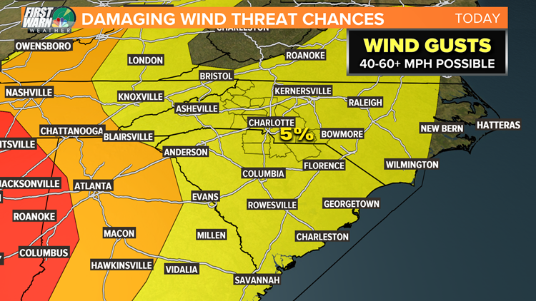
The storms could produce damaging wind gusts. An isolated tornado cannot be ruled out.
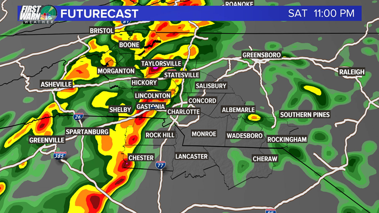
“There are a few kinks in the line,” Panovich said while examining futurecast radar. “Anytime I see that I worry about rotation in the line.”
WCNC
The best chance of seeing damaging severe weather would come in the form of straight line winds.
WCNC
Saturday afternoon’s forecast calls for a mix of sun and clouds. The more sun, the greater the risk later in the day.
“If we see any sunshine… there will be plenty of fuel for these storms to feed off of,” Panovich explained.
The National Weather Service could elect to issue a ‘watch’ ahead of the line, which means conditions are possible in the approaching hours for severe weather.
Severe weather ‘warnings’ are issued when a particular threat of severe weather is occurring or imminent.
For example, a Severe Thunderstorm Warning is issued when a storm is producing damaging winds of at least 60 mph or 3/4″ size hail, equivalent to the size of a quarter.
Panovich recommends everyone stays alert.
“Unfortunately it’s also a harder time of day to get warnings out to people,” he said.
Severe weather alert push notifications can be sent straight to your phone using the WCNC news app, which will alert you of severe weather nearby and also stream severe weather coverage from the First Warn Storm Team as conditions warrant.
More news from wcnc.com:
Suspicious man posing as Duke Energy worker, neighbors warn
Deputies warn of a police impersonator after woman gets pulled over by fake cop