- One year after devastating Panhandle wildfires, Canadian resident reflects on the work of rebuilding
- Hays County judge says software glitch caused some communication issues during wildfires
- FEMA deadline for Hurricane Helene recovery aid to governments, nonprofits extended
- Sellers and Rantanen are among the NHL trade deadline winners. Hurricanes and Boeser are some losers
- Hurricane forecasters express concern over NOAA job cuts impact
Severe weather, heavy rain likely later this week
Raleigh, N.C. — With balmy weather and a chance for severe weather later this week, it feels nothing like winter.
Highs on Monday topped out at 74 degrees in Raleigh and 75 degrees in Fayetteville. Tuesday and Wednesday will be similarly warm, with highs around 71 or 72 degrees in Raleigh. “There won’t be a lot of sun, but it’s going to be nice and warm,” said WRAL meteorologist Elizabeth Gardner.
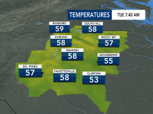
Lows will stay mild overnight Tuesday and Wednesday, hovering anywhere from the mid 40s to 60 degrees across central North Carolina.
According to Gardner, there will be a slim chance for isolated showers on Tuesday and Wednesday afternoons, but the real chance for stormy weather arrives Thursday night.
While it’s too early to predict the exact timing of the severe weather, Gardner said severe weather could move in Thursday night around 10 p.m. or midnight, bringing the chance for heavy rainfall, flash flooding, strong winds and isolated tornadoes.
The Triangle is under a level 2 risk for severe weather Thursday.
Download the WRAL Weather App for mobile weather alerts.
Forecast models show anywhere from 2 to 4 inches of rain from the storms, which would be heaviest overnight Thursday and into early Friday morning.
After the rain moves out Friday morning, we’ll be left with cooler days. Highs in the low to mid 50s are expected for Friday and Saturday, but the weekend will be dry.
