- Nearly every North Carolina wildfire caused by people, researchers say
- Weather IQ: How do wildfires ignite?
- EPA faces backlash for debris site near Los Angeles communities after massive wildfires
- California homeowners face potential hikes as State Farm defends wildfire rate increase
- After Hurricane Beryl, Texas lawmakers push for generators at senior living facilities
Over 87,000 now without power across NC; flash flood warning for Wake County
Raleigh, N.C. — Severe weather moved quickly through Wake County on Thursday, bringing the potential for isolated flooding, damaging winds and tornadoes. Schools closed early as a result, and people west of the Triangle were forced to take shelter during tornado warnings.
What to know
- A driver in South Carolina died after a tree fell on his car, the South Carolina Highway Patrol said.
- Wake County is under a flash flood warning for Wake County until 7:30 p.m.
- A flood warning for Cumberland County will be in effect from 7:40 a.m. Friday until 1 p.m. Monday
- Hoke, Cumberland and Scotland counties are now in a severe thunderstorm warning until 6:15 p.m.
- A Flash Flood Warning is in effect for Lee and Moore counties until 7 p.m.
- A Tornado Watch is in effect for Bladen, Duplin, Lenoir, and Robeson counties until 1 a.m.
- A Tornado Watch is in effect for Cumberland, Edgecombe, Franklin, Harnett, Hoke, Johnston, Nash, Sampson, Scotland, Wake, Wayne, and Wilson counties until 7 p.m.
- 70 mph winds were reported in the Triangle. Some wind speeds east of Raleigh reached 100 mph.
- Check Duke Energy’s website for the latest power outage report across the state and where you live.
Damage reports and images
6:43 p.m.: Duke Energy reports 87,561 are without power across North Carolina. There are over 45,000 without power in the Triangle area and 28,947 in Wake County.
6:36 p.m.: Amanda Lamb was with a family who was in their kitchen when they saw storms approach, and they went to their basement. As they were leaving, they said, a tree branch went through their kitchen wall.
6:35 p.m.: A flood warning for Cumberland County will be in effect from 7:40 a.m. Friday until 1 p.m. Monday
6:23 p.m.: Sarah Krueger reports the parking lot of an apartment complex at South Estes Road and Fordham Boulevard in Chapel Hill was beginning to flood after heavy rain fell during intense storms Thursday.
6:19 p.m.: Duke Energy reports just over 90,000 without power in North Carolina. That includes over 45,000 in the Triangle area and 28,801 in Wake County. The Triangle area is still reporting the most power outages in our state. Just over 21,000 outages are being reported in the Mecklenburg County area, the next most impacted area.
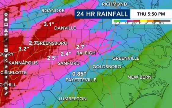
5:52 p.m.: Meteorologist Mike Maze had the latest rainfall totals over the past 24 hours. Areas to the west were getting over 3 inches in some locations.
5:45 p.m.: Katherine Skaggs sent us this Ring.com video from Youngsville.
5:42 p.m.: Duke Energy now reports power outages at over 96,000. That includes over 49,000 in the Triangle area, including 32,227 in Wake County.
5:39 p.m.: Cullen Browder was on Lake Boone Trail where a power pole snapped during the severe storms on Thursday.
5:34 p.m.: Gilbert Baez reports on the situation in the Fayetteville area.
5:33 p.m.: New storm warnings have been issued:
- Hoke, Cumberland and Scotland County are now in a severe thunderstorm warning until 6:15 p.m.
- A Flash Flood Warning is in effect for Lee and Moore counties until 7 p.m.
- A Tornado Watch is in effect for Bladen, Duplin, Lenoir, and Robeson counties until 1 a.m.
- A Tornado Watch is in effect for Cumberland, Edgecombe, Franklin, Harnett, Hoke, Johnston, Nash, Sampson, Scotland, Wake, Wayne, and Wilson counties until 7 p.m.
- A Severe Thunderstorm Warning is in effect for Robeson County until 6 p.m.
5:30 p.m.: Nash County Sheriff Keith Stone spoke with WRAL’s Julian Grace and advised residents to stay off roads while emergency crews work to clean up storm damage.
5:27 p.m.: Power outages are now over 101,000, according to Duke Energy’s website.
5:21 p.m.: A flood advisory has been issued for Wilson, Wayne, Johnston, Sampson, Harnett and Cumberland County until 11:15 Thursday night.
5:05 p.m.: Some areas of Bunn were hit hard. The Bunn Fire Department sustained some damage with a garage door to one of the trucks blown off. A gas station there lost some signage, which was blown off. Bunn High School also had some damage with baseball nettings blown from their original locations. Power lines were also down.
")
")
4:57 p.m.: A tornado watch issued earlier Thursday for Halifax County has been canceled.
4:51 p.m.: Duke Energy reports 98,596 are without power across our state. That includes 33,476 in Wake County, where the most power outages are being reported.
4:37 p.m.: A flash flood warning is in effect for Wake County until 7:30 p.m.

4:24 p.m.: Amanda Lamb reports a tree is down on Durant Road in Raleigh. It has taken down some power lines. Crews are working there to restore power. Duke Energy reports 33,160 are without power in Wake County.

4:13 p.m.: At Junction Six Forks Apartments on Six Forks Road and Monument Road, Adam Owens reports a limb from a nearby tree crashed into an apartment, taking off some siding and breaking a window. Owens also reports issues in that area continue as part of Six Forks Road is still closed due to trees and power lines are down.

4:10 p.m.: Duke Energy has announced 105,841 are now without power across the state, including 36,084 in Wake County.
4 p.m.: The Storm Tracker team is in Wake Forest where several trees fell at a home. Meteorologist Aimee Wilmoth and photojournalist Andrew Cumbee saw lots of trees down, including one that fell on a storage shed.
3:40 p.m. A massive tree crushed two cars on Brooks Avenue in Raleigh.
One of the owners said he had gotten out of his car minutes before the tree fell. The other owner said she was planning to go to work until the tree fell.
“Thank God I wasn’t in the car,” she said.


3:35 p.m.: There are 114,000 customers without power across North Carolina, according to Duke Energy.
3:30 p.m.: The storm was moving into northeast into Moore and Lee counties at 55 mph, WRAL meteorologist Mike Maze said. Winds could reach 60 mph.
“We’re not done with the severe weather just yet,” Maze said.
3:15 p.m.: Dashcam video from Christopher Buchanan of westbound I-440 before the Glenwood Avenue exit during the heavy storm that moved through Raleigh.
3 p.m.: The South Carolina Highway Patrol said a man was killed by a tree that fell on his car at 12:15 p.m. near Charlotte during severe storms.
2:55 p.m.: A severe thunderstorm warning is in effect for Edgecombe, Halifax, Nash, and Wilson counties until 3:45 p.m.
2:30 p.m.: Maze said the worst is over for counties west of Raleigh, but those east of Raleigh need to be prepared for fast-moving severe weather. A tornado warning expired in parts of Franklin and Nash counties at 2:45 p.m.
2:15 p.m.: Mike Maze said the worst of the storm is in Wake County. A part of the metal Exit 7 sign for Glenwood Avenue was on the side of Interstate 440. 77,000 customers were without power in North Carolina, the bulk in Wake County, which had more than 35,000 without power.
Power was estimated to be restored by 9 p.m.
“This storm is flying,” said WRAL Kat Campbell, emphasizing that isolated tornadoes and isolated flooding will be likely throughout Thursday afternoon even after the bulk of the severe weather moves out.
2 p.m.: Hail was reported in Durham and winds were as fast as 70 mph in Apex and Cary. Severe storms are expected to move through the Triangle very quickly before they affect Johnston and Cumberland counties.
“This is a serious storm,” said WRAL meteorologist Mike Maze.
Heavy rain and winds as fast as 70 mph are moving into Wake County and are expected to bring down trees. WRAL meteorologist Kat Campbell said storms are expected to be the worst in Cumberland and Johnston counties around 4 p.m. The storms will be moving through eastern counties and out of central North Carolina by 6 p.m.
12:07 p.m.: The line of storms, which is producing tornadoes, appears to be moving faster than models are showing. Crews are working to repair trees and powerlines that fell on Oakwood Avenue and Cypress Street in Wendell.
11:51 a.m.: Students on the UNC Charlotte campus said they heard tornado sirens and have been told to seek shelter due to a tornado warning in their area. The Charlotte airport is also under a tornado warning and people are being told to “shelter in place.”
11:22 a.m.: Durham County schools closing two hours early. The North Carolina Zoo closed for the day.
11 a.m.: We are beginning to see damage from storms, including a confirmed tornado that touched down in Kannapolis, which saw the worst of the storms. This video shows a tree with its trunk splintered stretched across a fenced yard.
Wild winds shown in uptown Charlotte.
Raging flood waters flowing past a parking lot and sidewalk.
Or this mail truck blown over by “powerful winds.”

A van and car crushed beneath fallen trees and branches.
UNC Charlotte students sheltered in the hallway during a tornado warning in their area.
The Carolina Waterfowl Rescue in Union county near Charlotte showed a live stream of their birds waiting out the heavy rain pounding the area.
Steady rain caused slow downs during morning commute, which had several accidents and closed roads.

10:44 a.m.: Johnston and Sampson County Schools have both canceled all after-school activities for Thursday due to a threat for severe weather. Granville and Person County Schools will release two hours early. All school closings.

“Damaging wind gusts are our main threat,” said Gardner. “Gusts could knock down trees and cause power outages.”
Back west, the approaching storm has caused 24 reports of tornado damage. The system brought thunder, lightning and tornado watches as it passed through Alabama and Georgia.

Between 2 to 3 inches of rain, wind gusts between 50 to 60 mph and isolated tornadoes will be possible with this system.
By 10 p.m., the threat should be in North Carolina’s eastern counties. By midnight, the threat should be mainly over. There could still be a chance of a shower in the morning.
To the west of the Triangle, heaver rain is expected with flash flooding possible. A flood watch has been issued for many counties in the WRAL viewing area from 6 a.m. Thursday to 1 a.m. Friday. Once the system goes through that part of the state, it is expected to begin to lose some of its punch as it moves east and off our coast by Friday morning.
Download the WRAL Weather App for mobile weather alerts.
After the rain moves out Friday morning, we’ll be left with cooler days. Highs in the low to mid 50s are expected for Friday and Saturday, but the weekend will be dry.

Heavy rains soaked large parts of Mississippi and Alabama early Tuesday, and two dozen counties in north Georgia will be under a flood watch through Friday morning, where some rainfall amounts could eclipse 5 inches, according to the National Weather Service.
Once the severe weather ends, the weekend will be cooler with temperatures near freezing Friday night and around 50 on Saturday afternoon. By Monday, temperatures will be in the upper 60s with Tuesday’s high expected to be near 70 with a 50 percent chance of rain .
