- North Carolina legislators fleshing out details on $500M in additional Hurricane Helene relief
- Dangerous travel conditions: Ice, snow and flooding possible
- How photos lost in disasters like Hurricane Helene find their way home, with a little help from people who care
- Dangerous travel conditions, ice/snow and flooding possible in the mountains Tuesday and Wednesday
- Weather Impact Alert: Dangerous travel conditions, ice/snow and flooding possible in the mountains Tuesday and Wednesday
Central NC under severe weather risk, damaging winds possible
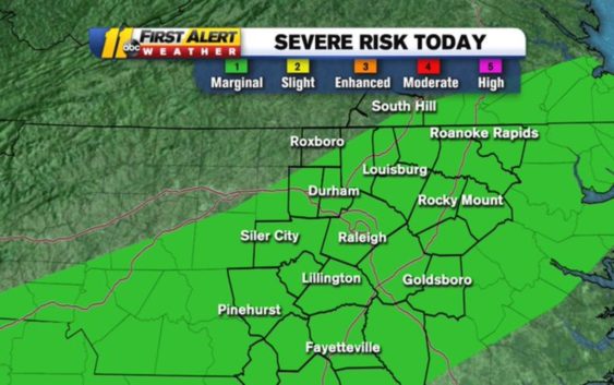
More rain is on the way for central North Carolina in the coming days, and with it comes a small chance for severe weather.
As most places are seeing a big warm-up on Tuesday morning, the National Weather Service has every county in the ABC11 viewing area under a Category 1 ‘marginal’ risk for severe weather on Tuesday afternoon.
The @NWSSPC now has every county in our viewing area under a Cat 1 (Marginal) of 5 risk for severe weather this afternoon. Biggest threat= isolated damaging wind gust or brief tornado. Almost 20 million Americans included in this risk. #ncwx pic.twitter.com/9M18QMXykT
— Don Schwenneker (@BigweatherABC11) February 11, 2020
The risk extends through Alabama, Georgia and the carolinas.
In North Carolina, rain should move in during the early morning hours with scattered showers stick around through lunchtime.
We expect a few periods of rain today with the best chance coming this afternoon and early tonight. Between 3 and 7 p.m., we’ll see some thunderstorms with possible gusty winds.
The biggest threat for us is an isolated damaging wind gust and even a brief tornado.
Tuesday’s threat comes days after storms caused power outages, property damage and several schools to close last week.
Copyright © 2020 WTVD-TV. All Rights Reserved.