- Dangerous travel conditions: Ice, snow and flooding possible
- How photos lost in disasters like Hurricane Helene find their way home, with a little help from people who care
- Dangerous travel conditions, ice/snow and flooding possible in the mountains Tuesday and Wednesday
- Weather Impact Alert: Dangerous travel conditions, ice/snow and flooding possible in the mountains Tuesday and Wednesday
- North Carolinians perplexed by unexpected DMV refunds tied to Hurricane Helene relief
Triangle under level 1 risk for severe weather this afternoon
Raleigh, N.C. — There’s a chance for thunderstorms Tuesday afternoon in the Triangle as two systems move toward North Carolina.
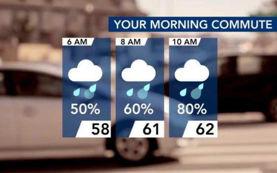
With an 80% chance of rain by 10 a.m., the morning commute could be wet Tuesday.
Following the rain, thunderstorms could move in after 1 p.m., particularly northwest of Wake County. Any storms should move out of central North Carolina around 6 p.m. The area is under a level 1 risk for severe weather.
Strong wind shear is expected Tuesday, but there will be weak forcing and limited instability, so storms won’t be extreme.
“We’re not looking at a widespread threat for severe weather or storms,” Gardner said.
Get WRAL Weather alerts on your device.
According to Gardner, the bulk of heavier rain will likely pass by the Triangle’s north and west.
Highs will be in the upper 60s and 70s throughout central North Carolina on Tuesday before dipping into the 50s on Wednesday, which will be sunny.
Thursday will be even warmer, with highs in the 70s, and a storm system in the western United States could bring storms to North Carolina again.
After that, temperatures plunge with highs in the 40s on Friday and Saturday before reaching the 50s on Sunday.
