- Seven months after Hurricane Helene, Chimney Rock rebuilds with resilience
- Wildfire in New Jersey Pine Barrens expected to grow before it’s contained, officials say
- Storm damage forces recovery efforts in Lancaster, Chester counties
- Evacuation orders lifted as fast-moving New Jersey wildfire burns
- Heartbreak for NC resident as wildfire reduces lifetime home to ashes
Warm Gulf, lack of El Nino mean active hurricane season, experts predict

-
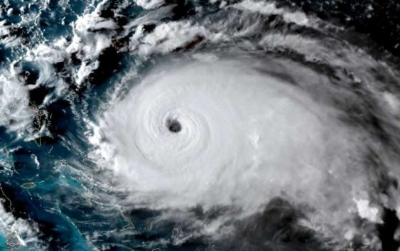
This satellite image obtained from NOAA/RAMMB, shows Tropical Storm Dorian as it approaching the Bahamas and Florida at 22:20UTC on August 31, 2019.
This satellite image obtained from NOAA/RAMMB, shows Tropical Storm Dorian as it approaching the Bahamas and Florida at 22:20UTC on August 31, 2019.
Photo: HO, Getty
This satellite image obtained from NOAA/RAMMB, shows Tropical Storm Dorian as it approaching the Bahamas and Florida at 22:20UTC on August 31, 2019.
This satellite image obtained from NOAA/RAMMB, shows Tropical Storm Dorian as it approaching the Bahamas and Florida at 22:20UTC on August 31, 2019.
Photo: HO, Getty
After four active hurricane seasons – each of which featured at least one violent Category 5 storm in the Atlantic – experts at Colorado State University are predicting another active hurricane season in 2020.
Significantly, forecasters said they anticipate an “above average probability for major hurricanes making landfall along the continental United States.” This is due to above-average Atlantic sea surface temperatures, a lack of El Niño in the tropical Pacific Ocean and other patterns setting up across the tropics.
The Atlantic hurricane season officially begins June 1, peaks in September and ends Nov. 30.
The predictions led by Colorado State University hurricane researcher and climatologist Philip Klotzbach, released Thursday, paint a disappointing picture for storm-weary coastal residents eager to catch a break.
– The forecast
According to the projections, which will be refined as the season nears, there’s a nearly 70% chance of at least one major hurricane – reaching Category 3 strength or greater with winds exceeding 111 mph – making landfall on U.S. soil in the Lower 48.
That translates to a 45% risk for the East Coast, including Florida, and a 44% risk along the Gulf of Mexico. Those numbers are up from a century-long average of 31% and 30% respectively. There’s also a 58% chance of a major hurricane tracking into the Caribbean, the outlook states.
Outside of major hurricanes, Klotzbach estimates a roughly 2-in-3 chance of a tropical storm or hurricane hitting the East Coast. That rises to 3-in-4 odds for the Gulf Coast.
Across the entire Atlantic, Klotzbach’s team is forecasting eight hurricanes to form. The seasonal average is 6.4. Of those, four are predicted to become major hurricanes, up from an average of 2.7.
A total of 16 named storms are anticipated to form in the Atlantic Basin overall, including tropical storms.
“The probability of a U.S. major hurricane landfall is estimated to be about 130% of the long-term average,” the outlook states.
The researchers do note that, while “it is impossible to precisely predict this season’s hurricane activity in early April,” all coastal areas should prepare for hurricane season regardless.
– Stacking up against other seasons
Eastern Atlantic sea surface temperatures, as well as those northeast of Australia, are both expected to trigger atmospheric circulation patterns that could enhance hurricane activity this year. Meanwhile, air pressure over the tropical Atlantic will have less of an influence, or could slightly suppress hurricane activity. Overall, the combination of factors stacks up to a boost in storm potential.
One of the more eye-catching numbers published by Klotzbach and his team Thursday is a prediction of Accumulated Cyclone Energy, or ACE, to reach 150 units. ACE is a measure of how much energy is spent by hurricanes in the form of damaging winds during a storm’s lifetime. It’s a proxy for how active a season is, and the Colorado State group is predicting that ACE will reach 150 units, which is above the long-term average of 106 units.
The National Oceanic and Atmospheric Administration’s Climate Prediction Center refers to seasons that feature more than 111 units of ACE as “above average.”
Each of the past four seasons, beginning with 2016, has an above-average ACE index. In 2017, which bore witness to hurricanes Harvey, Irma and Maria, is considered to have been “hyperactive” when using that metric.
Klotzbach’s forecast of 150 ACE units for the 2020 season would translate to more accumulated cyclone energy than during the 2016, 2018 or 2019 seasons. Per Klotzbach’s forecast, there’s a 1-in-5 chance that this season exceeds 200 units of ACE.
– Conditions at play
Among the leading factors behind Colorado State’s predictions are the likelihood that the El Niño Southern Oscillation, or ENSO, returning to a neutral phase. That means conditions will lie somewhere between a classic El Niño or La Niña.
During El Niño seasons, warmer waters gather over the eastern Pacific. That can enhance wind shear – or a change in wind speed and/or direction with height – over the tropical Atlantic. Wind shear can disrupt or even tear apart fledgling tropical weather systems, cutting back on the number of tropical storms and hurricanes that can develop.
The latest projections – included in the outlook – indicate ENSO neutral conditions or even a hint of a nudge toward a weak La Niña by late summer or early autumn.
Colorado State’s forecasts have historically proved to contain a fair degree of skill, though they are not precise and should not be taken as an indication of where a particular storm will strike.
Regardless of what happens, the report offered a sobering note to any coastal residents, advising them against becoming caught up in probabilities and numbers.
“Coastal residents are reminded that it only takes one hurricane making landfall to make it an active season for them,” the authors wrote. “They need to prepare the same for every season, regardless of how much activity is predicted.”