- National memorial to honor NC firefighter who died on duty during Hurricane Helene
- Gov. Josh Stein extends State of Emergency for western NC wildfires
- Governor Stein extends state of emergency for NC wildfire threat
- Governor Stein extends emergency in 34 NC counties amid wildfire threat
- Texans can buy emergency preparation supplies tax-free April 26-28 ahead of severe weather season
Tornadoes, damaging winds and power outages all possibilities this morning
Prepare to wake up to severe weather Monday morning as a line of strong storms passes slowly through the region.
“Please, if you don’t have to be out in the morning, don’t go to the grocery store, don’t go to the pharmacy, because it’s not going to be safe to be out and about between about 5 a.m. to 11 a.m.,” said WRAL meteorologist Mike Maze. “Stay home and turn on WRAL, we want you to be safe.”
Download the WRAL Weather app for alerts on your mobile device
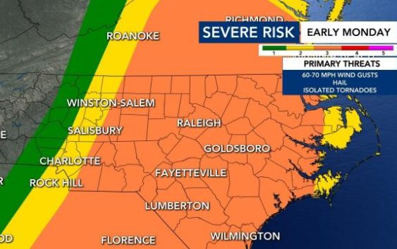
The entire viewing area is under a level 3, or enhanced, threat Monday morning, which means severe thunderstorms and tornado warnings are likely to be more persistent and widespread. A tornado warning was in place west of Winston-Salem by 4:30 a.m., and the Triangle is expected to follow suit.
“At some point toward daybreak, we will either have a tornado watch or severe thunderstorm watch,” Maze said.
Timing — A strong line of thunderstorms will slowly cross the region Monday morning. Storms were in central North Carolina by 5 a.m. and could arrive in Durham and other western counties by 6 or 7 a.m. By 7 or 8 a.m., the storms will be headed for Raleigh and Fayetteville. At 9 a.m., Raleigh could be right in the middle of the storm. Conditions will improve by 10 or 11 a.m.

Tornadoes and more threats — The areas shaded in yellow have a 10% chance for strong tornadoes, EF-2 or greater. In the event of a tornado warning in your area, seek shelter in an interior room — a closet, a pantry, a bathroom — with no windows.

Widespread, damaging wind gusts are possible, with gusts ranging between 20-30 mph with the potential to reach 70 mph or greater at times.
Golf ball-sized hail is possible.
As much as an inch of rain will fall Monday morning, creating the possibility for isolated flooding. Even after the storms move out, soaked roots and soil could produce some downed trees.

Power outages could be widespread through Monday afternoon.
“This system will move out in the early afternoon, but windy conditions continue through the evening,” Maze said. The National Weather Service has posted a high wind advisory for much of the state, including Cumberland, Durham and Wake counties from 4 a.m. through 4 p.m. Monday.

Prepare for a power outage
Gov. Roy Cooper sent out a press release Sunday afternoon urging North Carolinians to prepare for power outages and severe weather overnight.
People were encouraged to turn on weather radios or charge their devices before bedtime to make sure they can receive weather alerts in the middle of the night. Make sure your household knows where to gather to shelter in place if a tornado warning is issued. Keep batteries and flashlights handy and know how to report an outage to your power company. Sign up for WeatherCall.
The stay-at-home order will make grocery shopping more difficult once the severe weather is over. Prepare for power outages by having a cooler and ice ready to store refrigerated or perishable foods.

Food will stay frozen for 36 to 48 hours in a fully loaded freezer if you keep the door closed. A half-full freezer will generally keep food frozen for 24 hours.
If you lose power, notify the utility company right away, officials said. Don’t rely on your neighbors to do it for you.