- Seven months after Hurricane Helene, Chimney Rock rebuilds with resilience
- Wildfire in New Jersey Pine Barrens expected to grow before it’s contained, officials say
- Storm damage forces recovery efforts in Lancaster, Chester counties
- Evacuation orders lifted as fast-moving New Jersey wildfire burns
- Heartbreak for NC resident as wildfire reduces lifetime home to ashes
Rain moving in Sunday evening could turn into severe weather overnight
A severe storm system from the South will bring heavy rain and storms to central North Carolina Sunday night.
The low pressure system will bring storms to the region late Sunday night and into early Monday morning. Much of the state, including the Triangle, is under a level 1 risk for severe weather Sunday evening. Fayetteville and other areas south of the Triangle are under a level 2 risk.
Subscribe to get WRAL weather alerts on your device.
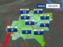
Clouds and rain showers moved into the Triangle as early as 2 p.m.
Temperatures will be in the lower 70s Sunday afternoon with showers likely between 3 and 8 p.m. Storms and heavy downpours are more likely in the overnight hours and into Monday morning, according to WRAL meteorologist Zach Maloch.
Gusty winds and isolated tornadoes will also be possible, particularly south of the Triangle.
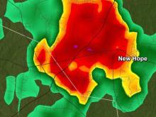
Track the rain with the DualDoppler5000.
Our southern counties could experience the worst weather, Maloch said. Up to 1.5 inches of rain could fall between Sunday night and Monday afternoon.
In the Triangle, the most rain will fall overnight and early Monday morning. Many people could wake up to a “soaking morning” on Monday before much of rain clears by noon.
The rest of the week should be nice with highs in the low to mid 70s before another chance of rain moves in Thursday.
