- Some in Hurricane Helene-ravaged North Carolina embrace Pres. Trump’s push to abolish FEMA
- Homes destroyed: Western NC families battling insurance disputes after Hurricane Helene
- Freezing weather, wildfire and flood risk forecast across Texas
- ‘Life-threatening cold’ expected as polar vortex stretches across U.S. after deadly weekend flooding
- Some in Hurricane Helene-ravaged North Carolina embrace Trump's push to abolish FEMA
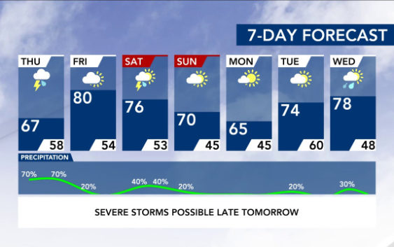
Strong to severe weather on Thursday could possibly slide south, east of Triangle

While we certainly are not out of the woods, new models coming into the WRAL Severe Weather Center indicate Thursday’s most severe weather may stay to the south of the Triangle and impact more of southeastern North Carolina.
“From what we’ve looked at this afternoon, the greatest threat may be well to our south and east and across the far southern part of the state, with widespread damaging winds, isolated tornadoes and hail,” meteorologist Mike Maze said. “We will watch to see if this trend changes, but that’s the way it’s looking right now.”
Maze said new models would be released Wednesday night that you can see on WRAL News at 10 on Fox 50 and on WRAL News at 11.
We are still in a Level 3, or enhanced risk, for severe weather but the newest models suggest we could miss the most dangerous weather.
“Thunderstorms ongoing in Alabama and Georgia, if they are quite numerous, that would block the moisture transport up toward us, limiting the severe weather threat, this model suggests,” Maze said.
The latest models have showers and storms moving south of Fayetteville. The strongest weather would come around 6 p.m.
“Notice how they make their way into southeastern North Carolina but they don’t really travel up to the north all that much,” Maze said when showing the latest maps during the 6 p.m. newscast.
That doesn’t mean we won’t see some kind of wet weather. Showers are possible for the area through 11 p.m. Thursday. Maze said by 3 a.m. Friday, the weather system would be off the state’s coast.
“The threat is there for the potential for strong to severe storms but, right now, what we’ve looked at, the evidence we’ve seen may keep it well to the south and east,” Maze said.
After the storms move away, Friday looks sunny and dry, although another system could bring rain and thunderstorms to the area on Saturday. There is a chance some of the storms on Saturday could be severe, too.