- Seven months after Hurricane Helene, Chimney Rock rebuilds with resilience
- Wildfire in New Jersey Pine Barrens expected to grow before it’s contained, officials say
- Storm damage forces recovery efforts in Lancaster, Chester counties
- Evacuation orders lifted as fast-moving New Jersey wildfire burns
- Heartbreak for NC resident as wildfire reduces lifetime home to ashes
Two beautiful days before severe weather threat
Tuesday and Wednesday will be gorgeous before severe weather moves into our area Wednesday night, according to WRAL meteorologist Elizabeth Gardner.
Tuesday and Wednesday will both be so beautiful that it will be difficult to stay indoors, Gardner said.
Tuesday’s high will rise into the mid 70s, and the day will feature plenty of sunshine. Most of Wednesday will also be nice, but temperatures will rise into the low 80s by the afternoon and evening.
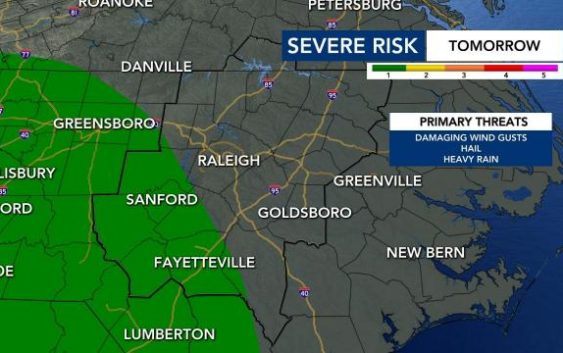
The best chance for severe weather comes overnight Wednesday, Gardner said. Areas southwest of the Triangle, including Fayetteville and Sanford, are under a level 1 risk for severe weather Wednesday evening.
The biggest risks will be damaging wind gusts, heavy rain and possible hail.
Since many people will be sleeping during the severe weather, it’s a good idea to download the WRAL Weather app so you can get alerts if needed.
Storms and rain will continue into Thursday morning. Thursday and Friday will be mild, cloudy days, with highs in the low 70s.

The weekend looks sunny and warmer. Saturday will warm up into the mid 70s, and Sunday will feature a high in the 80s.