LIVE: Gusty winds, flooding possible as heavy rain moves through central NC

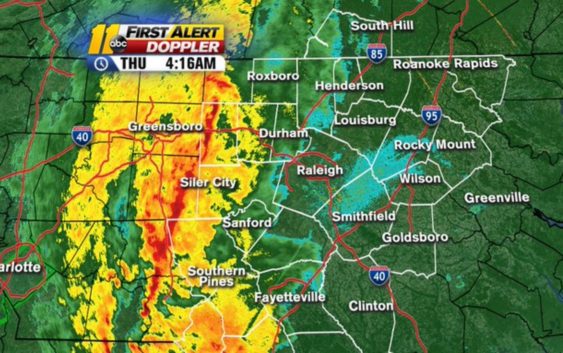
A corridor of heavy rain was slowly pressing to the east across western and central North Carolina. There were a few embedded thunderstorms as well, but none of these were causing any damaging wind gusts or hail.
4:15AM Update: No severe storms ATM, but torrential rainfall just approaching our western counties. This setup is almost like a rain band from a tropical system. Live updates all morning long on @ABC11_WTVD #rainfall pic.twitter.com/67c6U0tCo8
— 𝘿𝙤𝙣 𝙎𝙘𝙝𝙬𝙚𝙣𝙣𝙚𝙠𝙚𝙧 (@BigweatherABC11) April 30, 2020
However, some torrential rain is likely to cause some localized flooding today. That is most likely in the Triangle between the hours of 5 a.m. and 10 a.m. Total rain from this system should average between 0.75 and 1.50 inches, but in some of the heavier storms, there may be up to 2 inches. This will be enough to cause flash flooding of poor drainage areas.
The rain and thunder will taper to showers, then those showers will end from west to east this afternoon.
Copyright © 2020 WTVD-TV. All Rights Reserved.