- Charlotte-based marketing agency announces $20,000 Creative Campaign Grant to help communities after Hurricane Helene
- Artists transform hurricane aftermath into hoop-inspired masterpieces at Charlotte exhibit
- NC's cost for Hurricane Helene damage is nearly $60 billion, state says
- State to develop drone program to better respond to disasters like Helene, Florence
- South Carolina residents face deadline to get storm debris out to the curb after Hurricane Helene
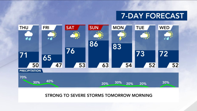
Very heavy, slow-moving rain to impact us all morning; isolated flooding possible

A slow-moving line of rain will soak central North Carolina between 4 a.m. and noon.
WRAL meteorologists Zach Maloch and Elizabeth Gardner said the chance for rain will increase as Thursday morning passes. At 3:30 a.m., rain was already falling in western counties, and Raleigh should see rain by 7 a.m.
Track the rain with the DualDoppler5000.
Chapel Hill and Durham should be in the clear by 11 a.m., Raleigh at noon, and by 1 p.m. the heavy rain should be out of our area completely, Maloch said. However, scattered showers will be possible the rest of the day.
“By 9 a.m., we’ll still be tracking this rain, but it could be in our eastern counties,” Maloch said.
Maloch said the rain will move very, very slowly, falling at a rate of up to 1 or 2 inches an hour. Isolated flooding is the main concern with these heavy downpours. Because the system is slow-moving, it will remain fairly organized. There’s a chance of some flooding in urban areas and locations where it may come down too quickly for the ground to handle.
Since many people will be sleeping when the severe weather begins, it’s a good idea to download the WRAL Weather app so you can be woken up by alerts if needed.
Scattered rain will be possible throughout the day Thursday after the heaviest band moves away.
The weekend is shaping up to be sunny and warmer with highs in the mid 70s on Saturday and mid 80s on Sunday before a chance of rain returns on Monday.
