- Cast of Scandal reunites to show support for western North Carolina after Hurricane Helene
- Tropical Storm Sara threatens to bring flash floods and mudslides to Central America
- Hurricane-stricken Tampa Bay Rays to play 2025 season at Yankees' spring training field in Tampa
- Utah scores 3 goals in 2 1/2 minutes in 3rd, Vejmelka has 49 saves in 4-1 win over Hurricanes
- Driver dies after crashing off hurricane-damaged highway in North Carolina
Timeline: Flash Flood Watch issued for Southeast Texas for Saturday; here's what to expect and when

We’re expecting heavy rain on Saturday that could lead to street flooding.
We’ll be on weather watch this Saturday as abundant moisture and an upper level disturbance combine to produce the threat for heavy rain.
A Flash Flood Watch has been issued for San Jacinto, Polk, Montgomery, Liberty, Colorado, Waller, Harris, Chambers, Wharton, Fort Bend, Matagorda, Brazoria and Galveston counties from Friday night until 7 p.m. Saturday.
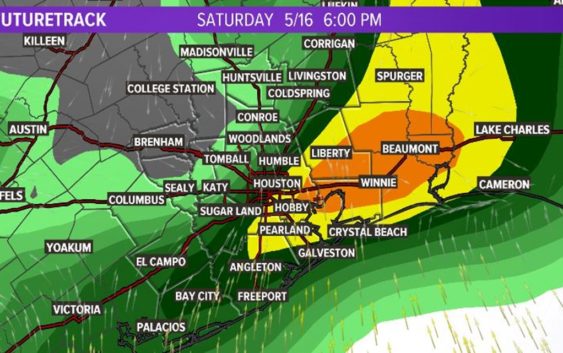
Back to back model runs suggest that storms will cross the Houston/southeast Texas area between 11 a.m. and 6:30 p.m. Saturday. After that, the threat will diminish quickly.
I expect widespread one to three-inch rainfall with isolated totals as high at 8 inches. That would lead to street flooding, and rises on creeks and bayous.
It does look like the heaviest rain moves east by early Sunday morning so I’ve lowered rain chances Sunday and completely removed them for Monday.
Otherwise, for today, expect more in the way of scattered showers and thunderstorms, especially in the heat of the late afternoon, as rain chances go up to 40 percent but you can think of that just like daily rain chances.
Here’s what Futuretrack shows for Saturday at 11 a.m.
Here’s what Futuretrack shows for Saturday at 6 p.m.
Get the KHOU11 app and stay close to the weather with us this weekend.