Severe Weather Moving Into The San Antonio Area Late Friday And Early Saturday

A wave of severe storms roared into South Central Texas late Friday evening and early Saturday morning, drenching the region with heavy rains.
The National Weather Service reported the “squall line” moved into the Hill Country around 10 p.m. Friday. “Damaging wind gusts, small hail, and torrential rainfall is occurring in some portions of the line,” NWS forecasters tweeted.
One model estimated the worst of the storms would arrive in the San Antonio metro area by midnight.
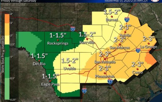
Forecasters advised that heavy rainfall and flash flooding in the San Antonio area was possible. One to three inches of rainfall was possible, they explained, with isolated amounts up to five inches, which could lead to flash flooding.
950PM radar update: A line of strong to severe storms is moving through the Hill Country and will move through the I-35 corridor between 11PM-1AM. Damaging wind gusts, small hail, and torrential rainfall is occurring in some portions of the line. pic.twitter.com/xIlndFUIJX
— NWS Austin/San Antonio (@NWSSanAntonio) May 16, 2020
Throughout Friday evening, the NWS tweeted out maps of West Texas and radar gifs illustrating the wave of storms sweeping eastward. The red box representing the extent of severe thunderstorm or tornado warnings consumed entire counties. Every hour showed the box creeping closer and closer to Bexar County.
Yellow was the color of the severe thunderstorm watch, which stretched from Laredo to the Texas-Oklahoma border.
“The primary threat remains strong damaging winds,” a forecaster wrote Friday evening. “Wind gusts to 55 and 61 mph were recently observed at Del Rio Airport. Cannot rule out 1 inch hail, however.”
It can be difficult or impossible to see flooding at night. There is no way to gauge how deep the water may be. NEVER drive through flooded roadways! Turn Around, Don’t Drown! pic.twitter.com/Gvecr2tpge
— NWS Austin/San Antonio (@NWSSanAntonio) May 16, 2020
Gov. Greg Abbott announced on Friday that he had activated state resources to assist with any emergencies and damages related to the weather.
“The State of Texas has placed these resources on standby as a precautionary measure to help respond to any potential severe weather and protect Texans across the Lone Star State,” Abbott’s office explained. “Over the weekend, Texans should pay attention to weather alerts and heed guidance from their local officials as these storms cross our state.”
The NWS reported San Antonio in 2020 was only about an inch and a half behind average rainfall totals. But the Edwards Aquifer level is only a foot about the mark where stage one water restrictions are triggered.
This story will be updated.
Norma Martinez and Fernando Ortiz Jr. contributed to this report.
Brian Kirkpatrick can be reached at Brian@TPR.org and on Twitter at @TPRBrian.
TPR was founded by and is supported by our community. If you value our commitment to the highest standards of responsible journalism and are able to do so, please consider making your gift of support today.