- One year after devastating Panhandle wildfires, Canadian resident reflects on the work of rebuilding
- Hays County judge says software glitch caused some communication issues during wildfires
- FEMA deadline for Hurricane Helene recovery aid to governments, nonprofits extended
- Sellers and Rantanen are among the NHL trade deadline winners. Hurricanes and Boeser are some losers
- Hurricane forecasters express concern over NOAA job cuts impact
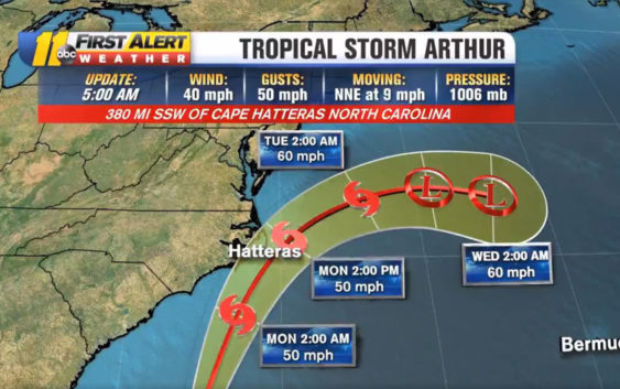
Tropical Storm Arthur may bring wind, strong rip currents to North Carolina coast Monday morning
The first tropical storm of the season, Arthur, has formed off the eastern coast of Florida Saturday night.
The National Hurricane Center (NHC) issued a tropical storm watch for a portion of the North Carolina coast after a tropical depression formed off the coast of east-central Florida on Saturday afternoon.
The watch is issued for the North Carolina coast starting from Surf City to Duck and including the Pamlico and Albemarle Sounds.
A watch is used when the risk of a hazardous weather or hydrologic event has increased significantly, but its occurrence, location, and/or timing is still uncertain. It is intended to provide enough lead time so that those who need to set their plans in motion can do so.
The tropical storm is moving north-northeast at 9 mph with sustained winds of 40 mph and gusting up to 50 mph. While the system will have minimal impact for central North Carolina, the storm will impact coastal regions on Monday. Heavy rains will be expected for the coast.
This is the sixth year in a row we’ve had a named tropical system develop before hurricane season begins, which is June 1.
Continue to monitor your local weather here.
According to the center, the depression will make for dangerous coastal surf conditions and rip currents as the system moves northward from Florida and into the mid-Atlantic for the next few days.
Dangerous swimming conditions for the next few days, especially tomorrow as Tropical Storm Arthur will be moving along our coast. pic.twitter.com/0WtP7iOFfN
— Steve Stewart (@StewartABC11) May 17, 2020
On Monday, Arthur will be along the North Carolina coastline but likely offshore. Some models bring it onshore near Ocracoke but the official track is 24 miles east of Hatteras.
Our current models have the most impact from Atlantic Beach to Hatteras between 7 a.m. and 11 a.m. Monday.
Copyright © 2020 WTVD-TV. All Rights Reserved.