- Sellers and Rantanen are among the NHL trade deadline winners. Hurricanes and Boeser are some losers
- Hurricane forecasters express concern over NOAA job cuts impact
- FEMA deadline for Hurricane Helene recovery aid extended again
- Tornado drills to take place at schools across North Carolina Friday morning
- Hays County emergency alerts cause confusion during Tuesday's wildfires
Tropical Storm Arthur approaching Outer Banks, will bring heavy rain east of Interstate 95
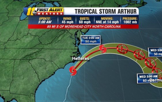
RALEIGH (WTVD) — Rain continues to spread inland this morning as Tropical Storm Arthur makes its final approach towards the Outer Banks for the midday today and will come very close to or may briefly make landfall over Cape Hatteras.
Regardless of whether this storm makes landfall or not, we will see heavy rainfall, mainly east of Interstate 95 where a total of 1 to 2 inches of rain may fall by early this afternoon, with higher amounts near the coast.
Regardless of whether this storm makes landfall or not, we will see heavy rainfall, mainly east of Interstate 95 where a total of 1 to 2 inches of rain may fall by early this afternoon, with higher amounts near the coast.
Rain will taper off this afternoon and evening from south to north with a brief window for dry weather this evening.
Breezy conditions will be found across the Triangle this morning, then winds begin to diminish into this afternoon as Arthur pulls away from the coast.
Copyright © 2020 WTVD-TV. All Rights Reserved.