- National memorial to honor NC firefighter who died on duty during Hurricane Helene
- Gov. Josh Stein extends State of Emergency for western NC wildfires
- Governor Stein extends state of emergency for NC wildfire threat
- Governor Stein extends emergency in 34 NC counties amid wildfire threat
- Texans can buy emergency preparation supplies tax-free April 26-28 ahead of severe weather season
Brad: “Major concerns for flooding in the mountains and foothills”
Life-threatening flood risk will threatens from the mountains through Charlotte and the Piedmont.
CHARLOTTE, N.C. — A potentially life-threatening flood event is unfolding Wednesday and Thursday across North Carolina and South Carolina, including in Charlotte, across the piedmont, foothills and in the mountains.
“Everything is saturated,” said WCNC Charlotte Chief Meteorologist Brad Panovich. “Even a light rain today would be a big problem.”
Panovich said there will be rain, heavy at times, for the next 12-18 hours.
A Flash Flood Watch is in effect for portions the entire region: Across the Piedmont and upstate South Carolina through Thursday morning. Panovich says several waves of heavy rain will likely through Charlotte Wednesday afternoon and evening.
Days of rainfall, combined with new accumulation, is straining already saturated grounds and rising waterways.
Before the heaviest rain Wednesday, Mountain Island Lake was rising.
Duke Energy controls the water level in Mountain Island Lake and Lake Norman through the release of water from their Catawba River dam.
“Duke Energy is aggressively moving water through the river system, including moving water through our hydro generating units and flood gates,” the power company said on its website. “Lake residents along the Catawba-Wateree River should make preparations for flooding conditions and closely monitor lake levels.”
Panovich believes those high rain totals in the mountains could cause problems along the Catawba River basin, where flooding is possible throughout the week.
Some areas have already seen over 7 inches of rain with at least another day of rain coming. Even after the last raindrop has fallen, the flooding risk will remain as water works its way downstream.
“Over a three or four day period, those totals start to add up,” Panovich said. “We’re at two-and-a-half inches in Charlotte already and it’s only Tuesday. Even if we see just another inch or two, that’s the most we’ve seen in a three or four day period in weeks.”
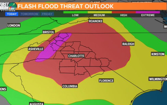
In the map below, the area shaded in red is a high risk for flash flooding with the mountains in an extreme risk.
Rainfall totals
As of Wednesday 12 p.m.
Lake Lure: 5″
Forest City: 4″
Fort Mill: 3″
Rock Hill: 2″
Weddington: 2.5″
Boone: 2.6″
Shelby: 2.62″
Matthews: 2″
The heavy rain is from a stalled system that will produce days of heavy rain showers and storms.
In the event of flooding, the National Weather Service would issue flood bulletins. The most severe conditions would warrant a Flash Flood Warning.
A Flash Flood Warning is issued when sudden, onset flooding is imminent or occurring. If you are in a flood prone area, you would be advised to move immediately to high ground. A flash flood is a sudden violent flood that can take from minutes to hours to develop.
It is even possible to experience a flash flood in areas not immediately receiving rain. Flooding can occur downstream or at lower elevations from where rainfall is occurring.
Be notified of Flash Flood Warnings in your area: Download the WCNC news or weather app to receive severe weather notifications for your location.
More news: