- National memorial to honor NC firefighter who died on duty during Hurricane Helene
- Gov. Josh Stein extends State of Emergency for western NC wildfires
- Gov. Stein extends state of emergency for NC wildfire threat
- Governor Stein extends state of emergency for NC wildfire threat
- Governor Stein extends emergency in 34 NC counties amid wildfire threat
Flash flood watch in effect, expect heaviest rain tonight and tomorrow
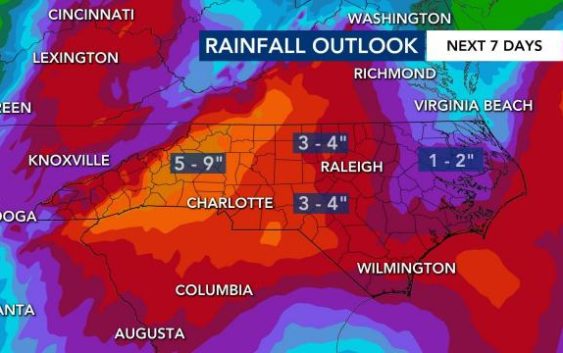
Heavy rain in western North Carolina led to landslides and rescues on Tuesday, and central North Carolina is at risk for flooding starting Wednesday evening.
According to WRAL meteorologist Elizabeth Gardner, the best chance for flooding in the viewing area will come overnight and early Thursday morning.
Gardner said there will be some light showers Wednesday morning, but after lunchtime, the rain could pick up. Waves of heavy rain could move through the region between midnight and 7 a.m., and then it will rain all day Thursday.
“Thursday may end up being the wettest day of the week,” Gardner said.
Counties just west of the Triangle are under a flash flood watch effective 5 p.m. Wednesday until 9 p.m. Thursday, including Chatham, Harnett and Cumberland.
The Triangle is not yet under any watches or warnings, but flash flooding could be possible overnight and Thursday.
“It’s really the Sandhills and our western counties that will see the brunt of it,” Gardner said.
Keep up with severe weather alerts here and download the WRAL Weather app to get alerts on your device.
Rain will continue Friday too, though it won’t be as heavy as Wednesday and Thursday. By Saturday, the Triangle could see between 2.5 and 4 inches of rain.

Rainfall levels are below normal for the month of May, so the rain is helpful, Gardner said. At 5 a.m. on Wednesday, Greensboro had already seen 2.25 of rain, and much more is expected to fall in the next 24 hours.
By Saturday, the rain will start dying down, but unsettled conditions will continue over the weekend.

The clouds stick around into Memorial Day weekend, although warmer weather returns. Saturday and Sunday high temperatures will get into the 80s, and some lighter rain is possible for the long weekend.