- Seven months after Hurricane Helene, Chimney Rock rebuilds with resilience
- Wildfire in New Jersey Pine Barrens expected to grow before it’s contained, officials say
- Storm damage forces recovery efforts in Lancaster, Chester counties
- Evacuation orders lifted as fast-moving New Jersey wildfire burns
- Heartbreak for NC resident as wildfire reduces lifetime home to ashes
Flooding threat, chilly winds make for nasty forecast
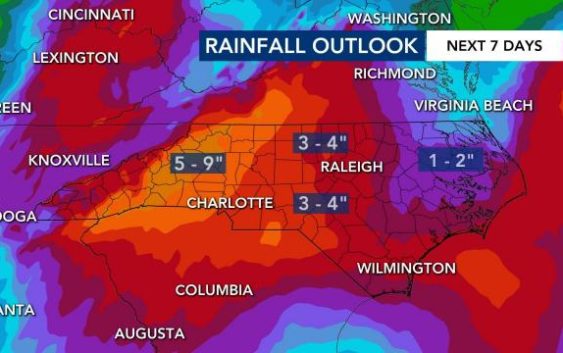
Heavy rain in western North Carolina led to landslides and rescues on Tuesday, and central North Carolina is at risk for flooding through Wednesday evening.
According to WRAL meteorologist Elizabeth Gardner, the best chance for flooding in the viewing area will come overnight and early Thursday morning.
Much of the state, including all of the Triangle, is under a flash flood watch. The North Carolina mountains could see between 6 to 8 inches of rain — which could be dangerous for drivers on the road.
The Tar River, in the Pamlico Sound, is expected to rise 12 feet, which does not put it at flood stage, but it comes close. The Deep River and the Rocky River will also rise in water levels.
Gardner said rain could pick up later this afternoon. Waves of heavy rain could move through the region between midnight and 7 a.m. Thursday, and steady rain will continue all day.
Areas of the Triangle could see an additional two to four inches of rain by Thursday at noon.
More than half of counties in the state are under a flash flood watch.

But the rain is not over yet.
“Thursday may end up being the wettest day of the week,” Gardner said.
Another band of rain could come from Charlotte and move into the state, she said, which could continue into Friday. The second band of rain won’t be as heavy as Wednesday and Thursday.

Rainfall levels are below normal for the month of May, so the rain is helpful, Gardner said.
By Saturday, the rain will start dying down, but unsettled conditions will continue over the weekend.

The clouds stick around into Memorial Day weekend, although warmer weather returns.
Saturday and Sunday high temperatures will get into the 80s, and some lighter rain is possible for the long weekend.