- NC Gov. Stein pledges continued Hurricane Helene recovery support in 100-day address
- Austin adopts new map that greatly expands area at risk of wildfire
- CenterPoint Energy accelerates infrastructure improvements ahead of hurricane season
- Carolina Hurricanes playoff tickets go on sale Thursday
- Ask the Meteorologist: Why do tornadoes target Tornado Alley, Dixie Alley?
Panovich: More heavy rain expected Wednesday, Flood Watch for entire Charlotte area
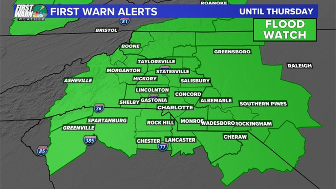
Wednesday will bring even more heavy rain with a greater threat of flash flooding in the Charlotte area, Brad Panovich said.
CHARLOTTE, N.C. — The entire Charlotte area remains under a Flash Flood Watch through Thursday as heavy rain is expected to last in the mountains and foothills before more rain Wednesday.
Chief Meteorologist Brad Panovich says the heaviest rain will be in the mountains overnight with chilly rain and drizzle over most of the metro. Overnight lows will dip into the 40s for the mountains and 50s in the Piedmont, including Charlotte.
A Flash Flood Watch is in effect for portions of Piedmont and upstate South Carolina through Thursday morning. Panovich says several waves of heavy rain will likely move into the Charlotte area Wednesday with the heaviest coming in the afternoon and evening hours.
“Another heavy band of rain will be on top of us,” Panovich said. “That’s the big area on the map where there is a medium threat of flash flooding. I expect that area will likely fill in.”
Panovich believes those high rain totals in the mountains could cause problems along the Catawba River chain, where flooding is possible this week. Some areas have already seen over 7 inches of rain fro this system with at least another day of rain coming.
“Over a three or four day period, those totals start to add up,” Panovich said. “We’re at two-and-a-half inches in Charlotte already and it’s only Tuesday. Even if we see just another inch or two, that’s the most we’ve seen in a three or four day period in weeks.”
Tuesday’s rainfall totals as of 10 p.m.
Charlotte: 2.5″
Boone: 2.6″
Shelby: 2.62″
Rock Hill: 1.5″
Albemarle: 1.94″
Monroe: 1.02″
The heavy rain is from a stalled system that will produce days of heavy rain showers and storms. It’s not going to be a total washout every day, but scattered showers and storms will bring heavy rain.
“The next three days, especially in the western Carolinas, flash flooding will be a huge deal,” Panovich said. “The next couple of days will be extremely, extremely wet.”
In the event of flooding, the National Weather Service would issue flood bulletins. The most severe conditions would warrant a Flash Flood Warning.
A Flash Flood Warning is issued when sudden, onset flooding is imminent or occurring. If you are in a flood prone area, you would be advised to move immediately to high ground. A flash flood is a sudden violent flood that can take from minutes to hours to develop.
It is even possible to experience a flash flood in areas not immediately receiving rain. Flooding can occur downstream or at lower elevations from where rainfall is occurring.
Be notified of Flash Flood Warnings in your area: Download the WCNC news or weather app to receive severe weather notifications for your location.
More news: