- Seven months after Hurricane Helene, Chimney Rock rebuilds with resilience
- Wildfire in New Jersey Pine Barrens expected to grow before it’s contained, officials say
- Storm damage forces recovery efforts in Lancaster, Chester counties
- Evacuation orders lifted as fast-moving New Jersey wildfire burns
- Heartbreak for NC resident as wildfire reduces lifetime home to ashes
Level 1 threat for severe weather on Friday before nice-looking Memorial Day weekend
Raleigh, N.C. — If we can get through one more day of rain and the potential for severe weather, we can finally start to dry out, warm up and enjoy the Memorial Day weekend.
Most of the state will be under a Level 1 threat for severe weather on Friday. Meteorologist Kat Campbell said the chance for severe weather is similar to what we experienced on Thursday with the chance for damaging wind gusts and maybe some hail.
“There will be a chance for isolated strong to severe storms (Friday), similar to (Thursday),” Campbell said.
Some areas will begin to clear out by 8 a.m. Friday with temperatures reaching into the upper 70s. The chance for rain and some storms will return by 5 p.m. Friday and linger into the evening before it finally starts to stop raining and we can begin to dry out.
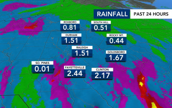
The Triangle area has already seen a bevy of rain with locations like Fayetteville (4.7 inches), Raleigh (5) and Durham (6.2) seeing slow and steady rain over the last 72 hours. That has led to rivers and creeks filling up and creating some isolated flooding in low-level areas.
“There are big changes in sight, and they are going to start (Friday),” Campbell said. “More sunshine in the forecast, but we are going to be watching for the potential for strong to severe storms again.”
The chance for rain will begin to lower on Saturday as the temperatures begin to rise. We’ll have a 30 percent chance for isolated showers on Saturday and a 20 percent chance on Sunday. Temps will hover around 80-85 degrees.
For Memorial Day Monday, temps will be in the upper 70s to low 80s. The temperatures will continue to rise with it being in the mid- to upper 80s by Thursday.