- National memorial to honor NC firefighter who died on duty during Hurricane Helene
- Gov. Josh Stein extends State of Emergency for western NC wildfires
- Governor Stein extends state of emergency for NC wildfire threat
- Governor Stein extends emergency in 34 NC counties amid wildfire threat
- Texans can buy emergency preparation supplies tax-free April 26-28 ahead of severe weather season
Possible flooding, severe thunderstorm risk in the Triangle and surrounding areas
Raleigh, N.C. — Many areas around the Triangle are under a flash flood watch until 8 p.m. on Thursday. This afternoon there are some patchy showers, mainly along the I-95 corridor from north of Wilson.
A Tornado warning was issued for Cumberland County, just to the north and east of Fayetteville until 4:15 p.m. Raeford was not included in the warning. Lighting and hail are a potential for the areas under a tornado warning this afternoon. WRAL meteorologist Aimee Wilmoth said she has not seen any signs of hail.
Hoke, Harnett and Moore counties were included in this warning. Downtown Fayetteville and Sanford are not included in the warning. The severe thunderstorm is moving to the north, away from these areas at 10 miles per hour.
A severe thunderstorm risk is still in effect for areas south of the Triangle, Wilmoth said.
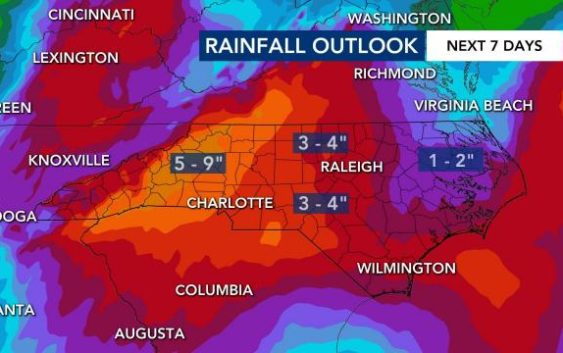
The last 72 hours has seen some impressive rainfall totals — one location in Durham had over six inches of rainfall. Raleigh, Clinton and Hillsborough got around five inches of rainfall today.
WRAL meteorologist Elizabeth Gardner said the Triangle has seen an average of 2 to 4 inches of rain, and we could see another inch or so before the storms let up.
Many areas around the Triangle are under a flood advisory until 1 p.m.
Stanley County, near Charlotte, saw of heavy rainfall which caused 50 roads to flood. Three people in the county had to be rescued from the water.
Gardner said some local rivers are rising, but they are unlikely to reach flood stage. The river most at risk is the Haw River in Alamance and Chatham counties, which could reach moderate flood stage near Burlington if heavy rain continues.

Most of this week’s heavy rain has been off to the west, prompting landslides and rescues in the mountains, but the rain shifted east Wednesday and Thursday, putting more of the area under risk for potential flooding.
One person died in Mount Airy on Thursday when a tree fell on his mobile home.
Thursday afternoon temperatures are in the mid-60s, and in the 70s in Fayetteville. In the warmer, southern parts of the Triangle more thunderstorms could develop, Gardner said.
Falling trees, power outages
Breezy conditions and saturated grounds caused several trees to fall across the viewing area overnight.
Wind speeds Thursday afternoon are at about 5 to 10 miles per hour, and gust at about 22 miles per hour. That’s not hard enough to knock down any trees on Thursday afternoon, Gardner said.
But, as thunderstorms continue to develop, the winds could pick up.
A large tree fell around 2:30 a.m. and took down power lines on North Estes Drive in Chapel Hill, leaving 450 in the area without power. In Chatham County, a tree fell on Hillsboro Street in Pittsboro, leaving 415 customers without power.
A large tree also fell overnight in Durham, stretching across Guess Road, and another fell Wednesday morning, hitting the front of Alumni Hall at UNC.
And in Apex, crews removed a tree that fell at Buckingham Way and Downing Place.
At 6:30 a.m., more than 6,000 were without power in the state. Many of those are in west of Charlotte, but around 1,200 are in our area.
The rain is also causing crashes. More than 1,000 customers lost power near Thornwood Drive in Sanford when a vehicle hit a pole around 1:45 a.m. A car also hit a power pole on Avent Ferry Road in Raleigh, but no outages were reported.
Looking ahead
Dry air moving from the deep south and the west will begin to move in.
“We’re going to be in what we call that dry slot by tomorrow,” Gardner said. “Not to say that we won’t see any rain at all, but it will be much drier.”
Gardner said we may even see a bit of sunshine, briefly, tomorrow.
Near Southern Pines and Fayetteville, Gardner said there is a higher chance of thunderstorms developing.
Skies will be clearing by lunchtime on Friday, Gardner said. But that will “destabilize” the atmosphere and set us up for more thunderstorms by Friday night.
Tomorrow the entire WRAL viewing area is under a severe thunderstorm risk.
After the storms pass, Saturday and Sunday temperatures will rise pretty quickly. Memorial Day is expected to look much different than the stormy weather we are seeing on Thursday.
More than half of counties in the state are under a flash flood watch.
