- One year after devastating Panhandle wildfires, Canadian resident reflects on the work of rebuilding
- Hays County judge says software glitch caused some communication issues during wildfires
- FEMA deadline for Hurricane Helene recovery aid to governments, nonprofits extended
- Sellers and Rantanen are among the NHL trade deadline winners. Hurricanes and Boeser are some losers
- Hurricane forecasters express concern over NOAA job cuts impact
Potential for Flash Flooding Today
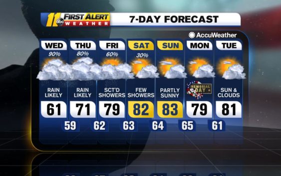
Rain continues to be the main concern in the near-term of this
forecast as a sprawling upper-level low remains stalled out. This
system is located across Tennessee River Valley, keeping central
North Carolina in a prime location to continue to experience waves of
heavy rainfall through today, although there is light at the end of
this very wet tunnel!
forecast as a sprawling upper-level low remains stalled out. This
system is located across Tennessee River Valley, keeping central
North Carolina in a prime location to continue to experience waves of
heavy rainfall through today, although there is light at the end of
this very wet tunnel!
Various flood watches/warnings blanket the WTVD viewing area from
from Durham/Wake/Johnston counties and to the southwest. While heavy
rainfall is still expected across this region again for today, the
overall risk for heavy rain should shift north and impact areas north
and east of Raleigh as the day moves along. Please watch out for flooding and
remember to never attempt to drive across flooded roadways!
A storm system over the Four Corners region this morning will help
lodge our latest storm system from its current location. Our current
cut-off low will drift toward the mid-Atlantic tomorrow and should
finally head out over the open Atlantic by Saturday afternoon.
This translates to one more very wet day for today with an additional
1-2 inches of rainfall for the Triangle area, then a wind-down with
the rain/thunder threat for tomorrow and Saturday before we finally
begin to dry out by Sunday. With that said, thunderstorms are
expected to become more driven by sunshine for tomorrow and Saturday
with the best opportunities for storms to occur during the afternoon
and evening hours. It will become warm and humid as well for
tomorrow and this weekend thanks to continued southerly flow across
the Triangle region.
High pressure will finally begin to nose into North Carolina by Sunday
and just in time to deliver a much-needed break from the rain for the
second half of this Memorial Day weekend! In fact, this area of high
pressure will become our primary weather driver into next week,
providing a much-needed reprieve from rain across the region.
Have a great Thursday and try to stay dry!
Big Weather
Check the radar anytime with the free AccuWeather app for iPhone and Android today!
Copyright © 2020 WTVD-TV. All Rights Reserved.