- One year after devastating Panhandle wildfires, Canadian resident reflects on the work of rebuilding
- Hays County judge says software glitch caused some communication issues during wildfires
- FEMA deadline for Hurricane Helene recovery aid to governments, nonprofits extended
- Sellers and Rantanen are among the NHL trade deadline winners. Hurricanes and Boeser are some losers
- Hurricane forecasters express concern over NOAA job cuts impact
Live Blog: Tornado warning for Gaston, Cleveland, and York counties
Storms will produce a risk for damaging winds. An isolated tornado cannot be ruled out. A flooding threat is also possible after days of rain caused saturated soil.
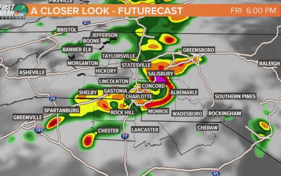
CHARLOTTE, N.C. — A line of strong-to-severe thunderstorms are forecast to move through Charlotte and the surrounding Carolina communities Friday. The storms will contain a risk for damaging winds, isolated tornadoes, and a flood threat, which is amplified by saturated grounds and swollen rivers cause by days of prolonged rainfall.
This is a live blog from WCNC Charlotte and the First Warn Storm Team. Refresh this page for real-time severe weather updates. We will be live coverage on WCNC Charlotte and streaming here throughout the evening.
Severe Thunderstorm Warning: Cleveland County, North Carolina
A Severe Thunderstorm Warning has been issued for upstate South Carolina, and the southern portion of Cleveland County, North Carolina.
The warning goes until 3:45 p.m., and could be expanded as the line of severe storms move east at 40 mph. The storms are capable of producing damaging winds and damaging hail upwards of one inch.
The same line of storms cause limbs to blow off of trees as it moved through Greenville County, South Carolina.
Threat of bowing line of storms
WCNC Charlotte First Warn Storm Team Meteorologist Chris Mulcahy says a forecasted “bowing” line of thunderstorms “shows that damaging straight-line winds are a legitimate concern.”
Futurecast radar and weather models show the line of storms moving through Charlotte after 5 p.m. and throughout the region between 4 and 7 p.m.
Severe Thunderstorm Watch issued
1:20 p.m.: The National Weather Service has issued a Severe Thunderstorm Watch for Charlotte. The counties under the watch include, but are not limited to:
- Mecklenburg
- Burke
- Cleveland
- Iredell
- Rutherford
- Cabarrus
- Lincoln
- Uion,
- Catawba
- Gaston
- McDowell
- Rowan
- York
- Chester
- Chesterfield
The Severe Thunderstorm Watch means conditions are favorable for the development of severe thunderstorms through 8 p.m.
A Severe Thunderstorm is defined as a storm producing 60 mph damaging winds and/or 0.75″ size hail, which is equivalent to a quarter coin.
“Atmosphere in vicinity of the stalled front should continue to destabilize with visible satellite imagery showing mostly clear skies across much of the Carolinas,” a forecast bulletin from the National Weather Service’s Storm Prediction Center. The bulletin came as forecasters prepared to issue the Severe Thunderstorm Watch.
The communities should monitor the weather. Individuals should make sure they have multiple ways to receive severe weather warnings from the National Weather Service, including access to a weather radio, the WCNC Charlotte mobile apps, and other resources.