- Sellers and Rantanen are among the NHL trade deadline winners. Hurricanes and Boeser are some losers
- Hurricane forecasters express concern over NOAA job cuts impact
- FEMA deadline for Hurricane Helene recovery aid extended again
- Tornado drills to take place at schools across North Carolina Friday morning
- Hays County emergency alerts cause confusion during Tuesday's wildfires
Tornado Warning in effect for Harnett, Hoke, Lee, and Moore counties
RALEIGH (WTVD) — A Tornado Warning is in effect for parts of Harnett, Hoke, Lee and Moore counties until 6:30 p.m.
ABC11 meteorologists said a possible tornado was seen near Southern Pines towards Whispering Pines.
A Severe Thunderstorm Warning is in effect for Cumberland, Harnett, Hoke, Lee and Moore counties.
According to the National Weather Service, threats include winds up to 60 miles per hour and penny-sized hail.
The warning expires at 6:30 p.m.
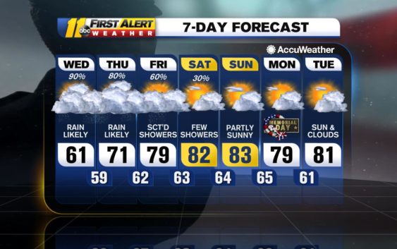
Sunshine finally returned today, but there is still some rain in the forecast this evening. A disturbance will move through central North Carolina bringing in a line of showers and storms mainly between 6-11pm. There is a chance that some storms could be severe. A severe thunderstorm watch is in effect for parts of central North Carolina unitl 10pm
A few pop up showers are possible Saturday due to a cold front still settled across the state. Rain won’t be widespread, and highs will reach the low 80s. The front slides east Sunday, but an isolated shower can’t be ruled out during the afternoon.
High pressure will develop across the region next week bringing a summer like pattern. Highs will reach the low 80s with a chance for a few isolated showers during the afternoon.
Have a great weekend!
-Brittany
Check the radar anytime with the free AccuWeather app for iPhone and Android today!
Copyright © 2020 WTVD-TV. All Rights Reserved.