- National memorial to honor NC firefighter who died on duty during Hurricane Helene
- Gov. Josh Stein extends State of Emergency for western NC wildfires
- Governor Stein extends state of emergency for NC wildfire threat
- Governor Stein extends emergency in 34 NC counties amid wildfire threat
- Texans can buy emergency preparation supplies tax-free April 26-28 ahead of severe weather season
Severe storms possible with damaging winds and hail tonight

-
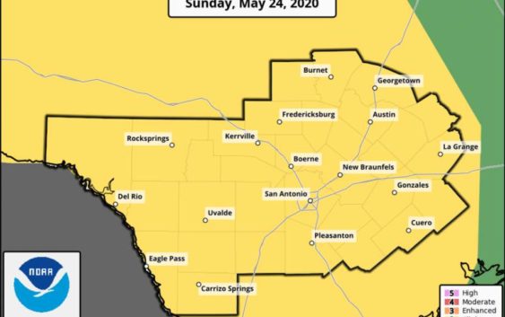
San Antonio will continue to stay in an active weather pattern over the next couple of days.
San Antonio will continue to stay in an active weather pattern over the next couple of days.
Photo: Courtesy NWS
San Antonio will continue to stay in an active weather pattern over the next couple of days.
San Antonio will continue to stay in an active weather pattern over the next couple of days.
Photo: Courtesy NWS
San Antonio will continue to stay in an active weather pattern over the next couple of days.
On Sunday night, a line of strong to severe thunderstorms will develop to our west near the Rio Grande and move eastward toward San Antonio late in the evening. These storms will carry large hail and damaging winds. Storms should weaken as they more closer to San Antonio, however we are still under a slight risk for severe weather.
Memorial Day, San Antonio has another chance for to see showers and thunderstorms, especially during the evening. These storms will again have the capability to produce hail and gusty winds.
Temperatures will be cooler on Memorial Day in the mid 80s.
Chances of storms will stay in our forecast through Tuesday and heavy rainfall bringing 1-3 inches with 4-5 inches in some isolated areas. Flash flooding and river flooding is also a concern.
Teresa Velasco is a digital producer for mySA and the San Antonio Express-News. She has a bachelor’s degree in broadcast meteorology. She uses data provided by the National Center for Atmospheric Research, the National Oceanic and Atmospheric Administration and others for her forecasts.